(Forecast is really easy the next few days… SUN and HOT. :))
April was strange in that it wasn’t actually that strange. It was slightly (very slightly) warmer than normal but really I would just describe it as normal as far as temperatures go. It was notably dry, with just 53% of the normal precipitation recorded. Snowpack is a lost cause now. Anyone with an eye to Mt. Arrowsmith will know that the South Island will basically have no snowpack this year. April did nothing to help that situation.
Anecdotally, I have heard that Sproat Lake is already at “August Lows”. This isn’t a big surprise again since anecdotally, if you look at Mt. Arrowsmith, it is a picture more usually seen in August rather than May.
The cause of this lack of snow and abnormally warm winter? “The Blob”… which is a kind of silly moniker given to the abnormally warm water off of the West Coast of North America.
But as was expertly pointed out by Cliff Mass on his weather blog a few weeks back… be careful of how you attribute cause and effect.
As he points out in a blog yesterday, what is truly stunning from this year is what the lack of snow was *not* caused by. It was *not* caused by a lack of precipitation, which has been the case in every other year of low snowfall. The cause has been normal precipitation falling mostly as rain at all elevations.
In his words:
There is simply no analog for last winter and this spring in the Northwest. It stands by itself.
Dr. Mass is a true skeptic when it comes to attributing our strange weather of the past few years to anthropogenic climate change. I say “true” skeptic because he backs his assertions up with peer reviewed literature and copious personal expertise. However, I do think he is often overly conservative to a fault. In my mind, as global warming and climate change is already well established to be happening then “natural variability” is by definition being affected every day by that global warming and climate change that has been observationally and experimentally proven to be occurring.
As for “the Blob”. Dr. Mass has a great post on how the mainstream media and even University press departments have misdirected the public on how it actually got there and how it is affecting our weather patterns.
Basically, the “blob” has been around for a couple years and is a result of persistent high pressure in the Eastern North Pacific area which has allowed for much clearer skies and thus greater solar input into the sea. This has allowed the sea to warm considerably and it now is affecting weather patterns. So what has been the cause of those persistent high pressure areas? Some (including me) might attribute it to an overly curved and stationary jet stream that may be caused by diminishing ice in the Arctic (and thus, Anthropogenic Global Warming). Another theory, which is supported by recent research, is that the high pressure pattern is being caused by abnormally warm subtropic ocean. Science is a wonderfully varied place. What all agree on (or more precisely none attribute to) is that the blob is *not* the cause of the warm weather or the cold in the east US but is instead a direct result of the same pattern.
No South Island Snowpack
The snowpack data and graph below are all that we need to see… that is, if you can even see the dark blue line on the bottom that represents this years snowfall.
The May 1 BC River Forecast Centre report note the emphasis:
Snow basin indices in the southwest portion of the province remain extremely low, continuing the low snow pack conditions of the winter of 2014-2015. Basins with record low snow basin indices for the May 1st snow survey (since 1985) include the West and East Kootenay, Okanagan, Similkameen, Lower Fraser, South Coast, and Vancouver Island (Table 1).
The average of all provincial snow water equivalent measurements for May 1st is 69% of average conditions. This is the lowest province-wide average for the May 1st bulletin in the past 31 years of record and is primarily due to the record low snow packs in the southern areas of the province.
The snowpack locally is 14% of normal. That is for the whole Vancouver Island region, north and south.
And here is the kicker we will have to prepare for:
With extremely low snow packs in the Lower Fraser, South Coast, Similkameen, East Kootenay, Skagit and Vancouver Island, runoff from snow melt will be limited. Seasonal low flows are expected to occur earlier than normal this year, very low flows can be expected in the summer unless significant rainfall occurs through the spring and summer.
This is a serious problem… we are still much luckier than, say, Sao Paulo Brazil, which is bringing in the military in case there is unrest if the City of millions runs out of water in the next few months. Or California which went under mandatory restrictions as of May 1st. We must work to avoid those situations. We have no excuse to say we were not warned.
Rainfall measuring woes continue at Airport.
Once again, the Airport station only recorded a small set of rainfall data. I have been unable to get in touch with anyone at Environment Canada to fix this… if you know anyone, let me know.
El Niño update
The latest El Niño forecast (May 14) is out, it’s main synopsis is:
There is an approximately 90% chance that El Niño will continue through Northern Hemisphere summer 2015, and a greater than 80% chance it will last through 2015….
…. Collectively, these features reflect weak to moderate strength El Niño conditions.
There is discussion in the forecast that some indicators are showing a possible increase in the strength of the El Niño event as the months progress. However, there is “considerable uncertainty” with the forecast especially at this time of year, so they are simply expecting El Niño conditions to continue but are not predicting it to strengthen at this time.
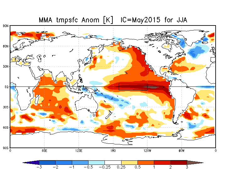
You can see the El Niño anomaly showing up in the rectangular box in the Sea Surface Temperature Outlooks in the next section. One thing to note, the waters of the Eastern Pacific are already abnormally warm as a whole. The El Niño area is even more abnormally warm. In other times… in all, there is an incredible amount of heat energy being released right now from the Pacific.
Outlooks — Spring and Summer looking warm and dry.
That brings us to the seasonal outlooks.
The NMME outlooks are available here. Take with a grain of salt.
Outlook for Temperature, Precipitation and Sea Surface Temperature for June, July, August (JJA):
2ºC Above Normal and Drier than normal.
(compared to last months prediction, warm and dry conditions predicted over broader section of Western Canada)
Below is the Sea Surface Anomaly map. I have retained last months prediction for the MJJ time period on the bottom. Notice the later period shows significantly more warmth in the El Niño rectangular box along the Equator. The persistent and abnormal warm water along the entire West Coast of the Americas is quite something, but especially the Northern portions.


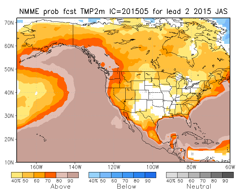
Outlook for Temperature Precipitation and Sea Surface Temperature for July, August, September (JAS):
2ºC Above Normal and drier than normal.
Here are the probabilities (the confidence levels) for those forecasts.
It all looks nothing but hot and dry.
That’s it! Check the data for the month is below!
Daily records set this month at the Airport (and compared to other stations* for “All Time”)
Three new Airport highs, one high rain.
- April 17 high 19.5º C : #1 is 26.7ºC in 1939 at Port Alberni.
- April 18 high 20.3º C: #1 is 28.3º C in 1934 at Port Alberni.
- April 19 high 22.9º C: #1 is 29.4 C in 1934 at Port Alberni.
- April 21 rain 13.2 mm: #1 is 40.1 mm in 1901 at Beaver Creek.
*Short Term Airport Records are compared to the 30+ year weather stations of record since 1900 at Beaver Creek, Port Alberni City and Robertson Creek.
April 2015 Minimum, Overall and High Daily Average Temps See last month’s and last April’s summary.
Alberniweather: 4.2º C, 8.8° C, 14.7º C
Alberni Elementary School : 3.9º C, 8.7º C, 14.6° C
Maquinna Elementary School: 3.9º C, 8.3º C, 14.1° C
Neptune Canada Station: NO DATA
Overall City Average: 4.00° C, 8.6 C, 14.46º C
Environment Canada Airport: 2.3º C, 8.4° C, 14.5º C
1981-2010 Env Can Normal (Rbrtsn Creek): 2.7º C, 8.5º C, 14.2° C
Precipitation for April 2015:
Alberniweather: 74.4 mm
AES: 77.2 mm
MAQ: 84.6 mm
NEP: NA (not measured)
Overall City Average: 78.7 mm
EC: NA (15.6 mm measured from only 5 days of reported data!)
1981-2010 Env Canada Normal (Robertson Creek): 143.6 mm
City Stations Temperature Difference from normal:
+1.3° C, +0.1º C, +0.26ºC
Official (Airport) Temperature Difference from normal:
-0.4º C, -0.1ºC, +0.3ºC
City Stations Precipitation difference normal:
-64.9 mm (54.8% of normal)
Official (Airport) Precipitation difference from normal:
—- not enough data
*Denotes incomplete data for the month
Comparison to recent Aprils at Alberniweather (unless specified)
- 2014: See the April 2014 Summary Here. Roughly the same as 2014.
- 2013: Cooler this year than 2013 but similar rain.
- 2012: Warmer this year than 2012 but drier.
- 2011: Way warmer this year than 2011 but drier.
- 2010: Warmer than this El Niño year and drier.
- 2009: Similar this year to 2009.
- 2008: Warmer and a a little wetter than 2008.
- 2007: Similar warmth to 2007 but drier this year.
- 2006: Similar this year to 2006.


