Well that was exciting.
In case you’ve been living under a rock (it may have moved), there has been a lot going on in the past 24 hours.
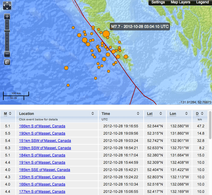
There was a major Earthquake, 7.7 on Haida Gwaii almost directly underneath the village of Sandspit. The picture below shows the earthquake and all of its aftershocks up until Oct 28 2:20PM PDT.
 This map is available at the excellent USGS website. You can listen to what it ‘sounded’ like to other sensors around the world here.
This was the largest Earthquake in Canada since 1959.
The quake was very strong for people on Haida Gwaii. It collapsed oil tanks, and caused cars to jump up and down according to phone calls from the region on Saturday night to CBC.
There was a Tsunami Warning issued immediately for the North and Central BC Coasts and an Advisory for Port Alberni. Low lying areas of Tofino were evacuated and they activated their Tsunami Warning sirens. Thankfully no major Tsunami was produced. But it was definitely there:
The Neptune project has sea pressure sensors at Folger Passage

Can you see when the Tsunami hit around 10PM PDT (5AMUTC)?
This is similar to what happened after the Great Japan Earthquake in March 2011.
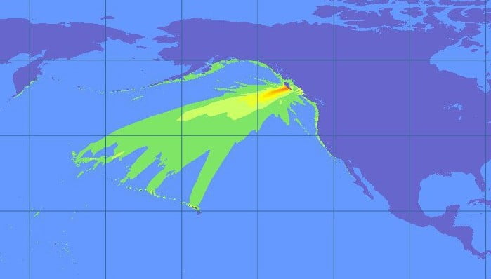
The worst of the Tsunami went due West away from North America (and most everybody else) and delivered a 2.5ft wave to Hawaii. Tofino only got 12cm. The Japan quake produced a 60cm wave in Washington state.
Had the Earthquake occurred off of the coast of Haida Gwaii rather than underneath it, it may have been a different story and we likely would have had a full Warning with sirens and everything in Port Alberni… even if the wave generated was still minimal compared to Japan.
Here is the final Advisory that lists all of the measured waves.
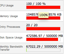
Here at Alberniweather there was a Tsunami at my website. This image shows the server was totally overloaded.

I think this has more to do with how my website works than with extreme traffic. But it was a good reminder that I need to rework my webpage. I eventually managed to turn off the auto-updating and that helped. It was my busiest time ever.

I thank you for coming here for information. Next time hopefully I’ll be able to provide more on the website.
The best place to go was Twitter and Facebook though. So please “like” the Facebook Page and follow the Twitter account. They did not go down at all and that is where most of the updates and information were.
This event and the Great BC Shakeout hopefully caused a few people to get their evacuation kits in gear. If we felt shaking, we would have literally only minutes to get to high ground. Would you take a car or go by foot? Personally, my home is above the Tsunami Inundation Zone… but many are not.
Plan for the worst, hope for the best:


Comments
4 responses to “Earthquakes – Tsunamis – Glad it wasn’t Worse.”
Thanks Chris, nice overview. I’m following you on twitter now. Lastnight was a bit like living in the dark ages (pre-computers) I was so confused by what I heard from news anchors. They really need to learn the difference between advisory and warning! Without FB, twitter and the internet in general I couldn’t imagine!
Yes, I was getting very frustrated with all of the news programs (all channels) that were saying there was a warning on the whole coast. There is a big difference between an Advisory and a Warning… informed people like here in Port Alberni and Tofino know that and it makes them react different and then get confused. Uninformed people simply end up very confused.
Next time I will have a better handle on the website so hopefully I’ll be able to update the website more reliably which automatically updates the alberniweather facebook/twitter feeds and then I can concentrate on that and answering questions in the Facebook/Twitter timelines. It was pretty scattered last night.
Having grand-babies living by the dyke I was scouring every gov website trying to figure out what to tell my daughter was on the way. FB told her she should run for the hills because Tofino had the sirens and evacuations. It was with your help that I could give her an answer I felt confident about. Thanks again!
I have a feeling the confusion was partly brought on because officials were confused by it being a thrust instead of the usual strike slip for that area. Will try to add photo below.
http://neic.usgs.gov/neis/eq_depot/2012/eq_121028_b000df7n/neic_b000df7n_m.jpg
It all turned out okay this time, and ended up being a very useful test. One fascinating thread on Chris’s wall really highlightd the need for more public education the public warning system. It’s a great system, but only if the public knows what the information means and how to react as a result. The TV media was no help at all.