
Year: 2014
-
Mostly dry but cool week ahead – hot next week perhaps?
Summary: Don’t expect any super hot days in the next week or so. We might get lucky and have the sun come out for a little longer than expected one day, but mostly this week is going to be pretty variable, with cloud, sun, rain and wind all taking turns. Temperatures should be a little…
-
Interesting (showery/stormy?) couple days, then good conditions for AC/DC Saturday
Update: 2PM The first storm cell has moved through and there hasn’t been any more lightning detected on the Island but another couple cells look to be moving up from the Cowichan/Nanaimo areas along the same lines. Expect more showers in the next hour or so. Update: 1PM Lightning detected in past few minutes along…
-
May 2014 Summary – Warm and Dry Weather Causes Snowpack to Disappear
Pleasant May weather setting us up for Dry summer? May was above average for temperatures, and well below average for rainfall. Check out the full report below. Snowpack is gone On average, the snowpack usually disappears sometime in July. However, the BC River Forecast Centre shows the snowpack pack effectively disappeared by the end of May, 2 weeks earlier than last year…
-
Another off and on week. Rain Thursday. Sunny AC/DC
The forecast is kind of all over the map this week. But generally it should remain pretty decent with only a slight chance of rain Tuesday /Wednesday and plenty of sunny breaks throughout and warm temperatures. This should hold until Thursday night or Friday when we have what looks like a more substantial system coming…
-

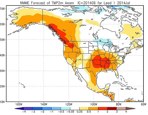
Warm weekend coming, and so is El Niño
Update: Friday June 6: Just a quick update to say there chance of showers on Saturday evening has remained about the same in the forecast and a few very light showers have popped up on the West Coast for Sunday. Nothing serious though and still warm. With sun returning Monday. …………. Nothing to complain about…