

Back to work and the bus
I am back to work at VIU this week and this is my first post from the bus in quite a long time! Last year I had started to catch the bus to VIU from Woodgrove as it made for a shorter commute, but I found I missed the extra quiet time on the bus, hated the extra driving, and couldn’t/didn’t blog as much here!
So I am again on the bus from Parksville, I hope it means more time for this blog. 🙂
First rainy week since June.
The weather has certainly switched from our long, mostly uninterrupted, dry and hot spell from the 2nd week of July to last week.
We have received about 15mm of rain since Saturday.

If you, like me, have been doing any digging in the yard or garden though you’ll know that the moisture only reaches a few centimetres down. Underneath is still bone dry so while I am sure the gardens and forests, and salmon will appreciate the rain, it has still been a hot and dry past month.
Another possibly stormy day, then rain, then sun.
We have a mixed bag this week. Tuesday will feature showers but also again the possibility of Thunderstorms in the afternoon. You can see them focused on the East side of the Island in the 2-5PM period.

These should clear up by sunset but could produce significant downpours. Be careful on the roads.
On Wednesday we have a final sweep of a front coming down from the Northwest across the Island.

It will reach Port Alberni and the central Island by 2PM and the rest of the Island by Wednesday evening. This should produce widespread rain possibly up to 20mm in Port Alberni! Another good drink for the gardens! This might even be enough to knock down our fire rating again!
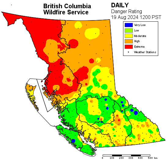
Fire danger moderate to low – but please be careful.
The good news is the past few days of, and upcoming, rain has and will reduce the fire danger. Here is the current rating.
Return to sun and warm, but short lived.
The rain will quickly move off Wednesday night and by Thursday afternoon it should be clear and warm (up to 26°C). Friday should be similar but we will see showers again on the weekend.
The long range forecast suggests we could see a longer period of sun and warmth again by late next week. We’ll keep an eye on it, and I hope I’ll be blogging about it regularly again. 🙂
Sign up to Mastodon for updates
Finally, I encourage you to make an account at joinmastodon.org to follow this blog and and get other up-to-the-minute updates.
Have a great Tuesday!