Looks like we have another tropical river setting up and another ex-Hawaii Hurricane feeding moisture to us in the next few days including over Thanksgiving.
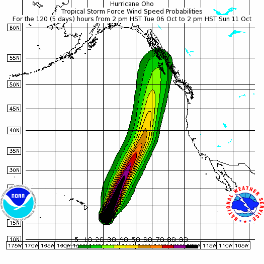
Hurricane Oho (NOAA Page here) is a Category 1 Hurricane currently losing steam near Hawaii. The interesting part is it’s predicted path. This is a 5 day track (to 2PM Sunday) as of this Tuesday evening.
The wind potential is not huge, but it is a very vigorous system as we can see from the UWash maps as it travels. Below you see Wednesday 11PM (pink), Thursday 11PM and Friday 11AM as it travels up from the SouthWest.
If this track holds then rainfall will be lessened but still nothing to sneeze at. UWash is predicting up to 128mm between Wednesday morning and Monday afternoon. The majority predicted for Sunday/Monday.
But there is not agreement of course.
Here is the Canadian Ten Day from SpotWx. 186mm, mostly Sunday.
The US GFS model is the least worrisome with only 80mm.
And the Canadian multi-model consensus is 137mm.
It all makes for a wet few days, but not necessarily of great concern.
Forecasts can certainly change however. The ex-Hurricane’s path appears to be influenced by the large low near the Alaska Panhandle. That low is what actually swings rain into us and the question is whether it swings Oho into us as well.
Will keep you posted. I will try to push out the September Summary tomorrow so that that is out of the way before Thanksgiving.


