First an update on El Niño, or the lack thereof. The latest EL NIÑO/SOUTHERN OSCILLATION (ENSO) report is out from the NOAA Climate Prediction Center. Their observation:
During November 2012, the Pacific Ocean reflected ENSO-neutral conditions.
…it is considered unlikely that a fully coupled El Niño will develop during the next several months. ENSO-neutral is now favored through the Northern Hemisphere winter 2012-13 and into spring 2013.
Since El Niño and its counter La Niña have a strong effect on our local climate and weather patterns, especially in winter, the lack of either of these ‘modes’ means it is much harder to predict overall weather patterns further out than the standard 5-7 day forecast.
So we are on our own this winter. Just gonna have to roll with the punches. 🙂
Focusing more on the immediate future. That ‘snow’ word has magically appeared in the forecast! You might have already noticed some sleet mixed in when it has been raining hard as the temperatures have cooled and the heavy rains pull more heat out of the air and bring the freezing level down.
This mornings images (just updated in the last couple minutes) shows the winds still blowing from the South and West around most of VI.
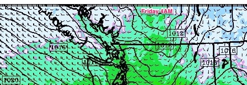
Yesterdays forecast run showed by Friday morning, the winds will turn around and start to blow from the Northwest, bringing more pronounced cold to all areas of the Island. White areas are freezing or below.
On Saturday evening Sunday morning things get interesting as a weak wet front pushes down against the cold… Top image below show rain showers pushing down, bottom image is temperatures.
This should set us up for some mixed rain and snow on Sunday morning.


Comments
2 responses to “Neutral Pacific and the “S” word”
It’ll be interesting to see what happens – EC is calling for simply, “snow or rain” in Sunday’s forecast, but the GFS is predicting very little in the way of precipitation for Saturday/Sunday.
Ya I saw that too Bill. We will have to see just how much precipitation we actually get. The heavier it is, the greater the chance for heavy sleet. The lighter is though, it might keep us colder and have flakes in the air. Will be interesting.