Well, it’s the morning after and for the most part we have come away from yesterday’s potentially damaging storm with very little damage.
Highlights:
Peak winds at Alberniweather: 54kph at 11PM
Peak winds measured by EC.
Estevan Point (West Vancouver Island) 122 km/h
Comox Airport 94 km/h
Grief point (near Powell River) 93 km/h
Sisters Island (Strait of Georgia) 102 km/h
Discover island (off Victoria) 103 km/h
Victoria gonzales 76 km/h
Saturna Island 93 km/h
Tsawwassen ferry terminal 81 km/h
Point Atkinson (West Vancouver) 91 km/h
Peak winds measured by Islandweather.ca
Alberni Elementary: 52kph
Courtenay: 80kph
George Jay Elementary (in Victoria): 70kph
UVic: 80kph
Trial Island (off Victoria): 105kph
So while we got plenty of wind in spots… And there were lots of ferry cancellations, power outages, and tree branches on the road, the question is, why didn’t we get as strong a storm as we thought we might.
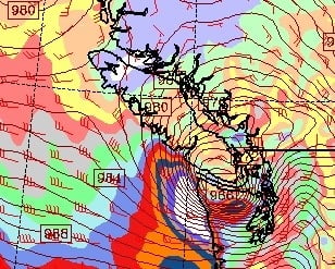
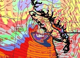
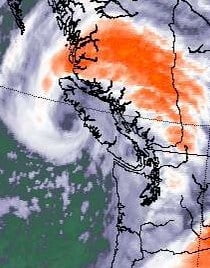
Basically it went north. Here are the runs of the models on Sunday morning. NAM on the top, GFS middle, and actual satellite picture bottom.
The NAM was much farther south and was the strongest, This gave great cause for concern for the folks in Washington State. The GFS had it coming up Barkley Sound, which made us nervous. But as you can see it ended up near Kyuquot.
Meteorologist Scott Sistek of KOMO news in Seattle said on Twitter:
Well one thing is for sure, the NAM model sure took a credibility hit tonight. GFS/Euro was much closer to reality. Had the NAM model we saw this a.m. verified, it would have been historic and very damaging storm, so thus some alarm today.
.
I don’t have access to the Euro model (you have to pay for that) but the storm definitely went further north, and was a little weaker than both other models.
Oh well, it is always good to be prepared. It was still a significant storm, it even produced 2 waterspouts in off Cape Beale and Barkley Sound. So especially for this time of year, it was strong. And let’s not forget about all the rain that fell. In fact, we received over 70mm of rain through the weekend. Which is more than our normal for the entire month of September (49mm).
Is this storm a sign of the season to come? Hard to say. Let’s hope perhaps this is one of the strongest. Better a few branches down than whole groves flattened, or major flooding on 3rd avenue.
We will get some breaks from the showers today, but it will still be pretty wet. Tuesday, Friday, Saturday and Sunday all look pretty wet.
Happy Monday!


