Flood Watch Re-issued for Somass River/Sproat/Ash.
The Tseshaht First Nation continue to sandbag their properties along the river to try to prevent a repeat of last year. Hopefully the sandbags will only be wet from the rain, and not from any flood waters. If you would like to help, please head down to the Administration building by the Somass River Bridge.
The BC River Forecast Centre has issued a Flood Watch
Based on the forecast rainfall and streamflows in the Ash River and Sproat River, the estimated flows in the Somass River may reach between the 5-year and 10-year return period flow. This is about 10 to 15% lower than estimated flows in the Somass River from December 2014 that, combined with high tides and storm surge, resulted in flooding in the Port Alberni region.
Flows in the Somass River are expected to increase by Tuesday morning with potential for flooding in low-lying areas by Tuesday afternoon and additional streamflow increases by early evening due to an added pulse of snow melt from higher elevation in the basin.
The Rain Forecast
We have more rain starting around 1AM Tuesday morning.
We have an interesting pattern shaping up where the rain will begin and then will slip to the south around noon. The end of this first wave unfortunately coincides with a significant 10ft high tide at 10AM.
By 5PM it is supposed to slip all the way down to Seattle.
This is one part of the forecast that will have some uncertainty in it since if doesn’t slip as far south, or lingers in the south, then we will get more or less of our own share of rain.
The rain will return by 10PM Tuesday which again will coincide with high tide but it will only by 8ft at 11PM.
The totals for the first wave… we’ll take from the 4PM Monday to 4PM Tuesday look which currently says 30mm (1.2in).
The second wave 4PM Tues-Wednesday will be the variable one but it is currently set to be fairly small, 16mm (0.6in).
16mm is predicted to Thursday afternoon as a strong system pushes through but I’ll get to that later this week.
Wind Potential – Not Much – Until Friday
After last nights somewhat surprising windiness (and surprising lack of BC Hydro outages locally, though there were some) here’s a look at the Wind potential. With the soaked ground and drought stressed trees, I have heard of a lot of smaller trees falling even without any wind.
That said, there does not appear to be any serious wind potential from the next couple days.
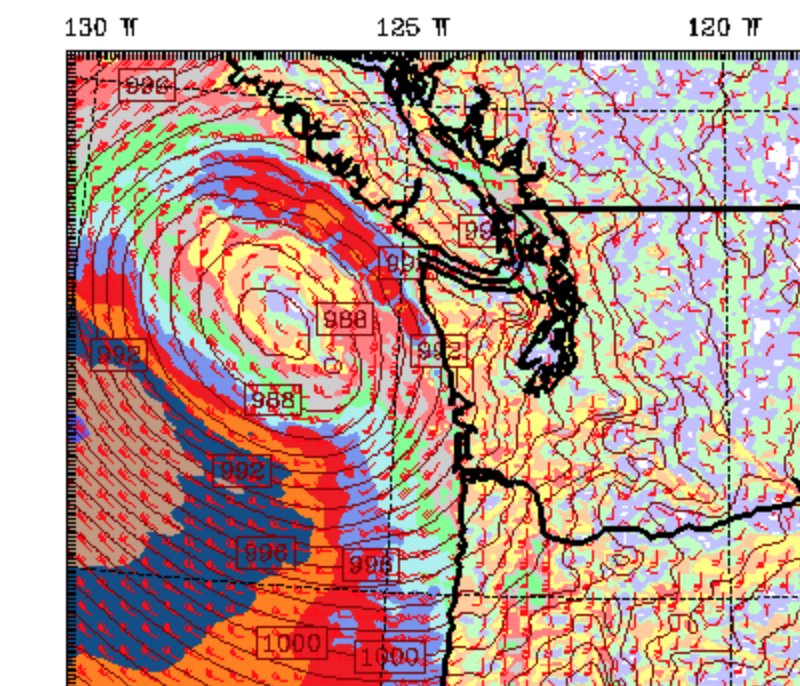
However, this picture at the tail end of the 3day short term (Friday 4AM) sure left a big first impression:
That is one heck of a major low pressure area.
Where is going to land? A quick look at the extended UWash forecast tells us it’s headed into Washington State but a low of that magnitude (96.2kPa when it reaches the North Island) is definitely worth keeping an eye on.
Stay safe out there.


