Welcome to Daylight Savings Time!
Where’s the coffee?
So as was forecast, we missed out yesterday as the South Island, Vancouver and northern Washington got pounded with a pretty violent storm. Check out the video from the Washington State San Juan Ferry. Rock and Roll! The free car wash would have been great if it wasn’t salt water… and didn’t involve pushing one car into another!
https://www.youtube.com/watch?v=fXNni1mcA1U
Judging by the wind spray on the water the winds in that video were probably in the 35-40knot (60-70kph) range.
All we got from the event was a little bit of rain.
The week this week will be much more variable. We’ll start out with a chance of showers Monday and Tuesday (it was raining fairly heavily in Coombs this morning but not anywhere else).
By mid week we should see some warm sun in the afternoons though our morning temperatures will be close to or just below freezing.
There is rain coming again on the weekend but we’ll see if the forecast changes at all.
El Niño weakening – February smashed global warmth record – Unprecedented Arctic Heat
The latest El Niño forecast and discussion has been posted.
The conclusion is:
A transition to ENSO-neutral is likely during late Northern Hemisphere spring or early summer 2016, with close to a 50 percent chance for La Niña conditions to develop by the fall.
So that’s pretty much it for El Niño, however, its effects will linger for a while longer:
El Niño has already produced significant global impacts and is expected to affect temperature and precipitation patterns across the United States during the upcoming months (the 3-month seasonal outlook will be updated on Thursday March 17th). The seasonal outlooks for March – May indicate an increased likelihood of above-median precipitation across the southern tier of the United States, and below-median precipitation over the Midwest and part of Pacific Northwest. Above-average temperatures are favored across the North and West, with below-average temperatures favored in the south-central region.
It is worth pointing out at this time that the last major El Niño event occurred in 1998 which also coincides with the year the fake climate sceptic community loves to try to say that the earth ‘stopped warming’ or some such thing.
Well… this year’s El Niño has been just as stronger or stronger than 1998, however, it hasn’t been so strong as to be expected to produce something like this:
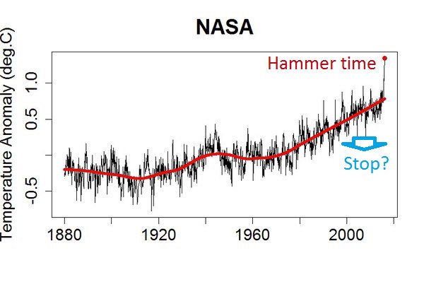
That last data point is February 2016 which spiked a full 0.46ºC above the last record high February. A stunning, and rather foreboding picture of a world undergoing very rapid change. This is obvious the largest monthly temperature departure from normal ever recorded.
Another version of the same temperature but using the full temperature data set with a strange nod to a certain former rap star.
What is causing the huge uptick? That remains to be seen. Where is the heat being felt the most. Well, a good candidate is probably the Arctic circle.
Consider this graph from Svalbard, Norway which is at 76º North latitude.
Last 30 days: Average temperature was -3.3 °C, 12.9 °C above the normal. Highest temperature was 5.4 °C (13 March), and the lowest was -12.1 °C (13 February).
When the low doesn’t even reach the normal average daily temperature (1960-1990) then you know you are in uncharted waters.
The outlook for Northern Hemisphere spring is more warmth.


