There were literally dozens of records set yesterday in BC. Too many to list.
Once again our micro climates in the Valley made for a little more complicated picture but as we all know, and is born out in all the historical data the city and Inlet is generally hotter than the Valley areas. While the islandweather.ca stations in Port Alberni are not official for Environment Canada, the reality of the situation is that all of the city stations were above the record set by the old city of Port Alberni station of 28.3 in 1934. The lowest temperature from yesterday in thr city was 28.4°C at the Maquinna Elementary station. The highest was 28.9°C at Alberni Elementary and the Neptune station.
The Airport got up to 27.9°C, smashing last years high (20) for the station but also easily bettering than the Beaver Creek record for the day which was only 26.7°C in 1915.
So as far as I am concerned Port Alberni had its hottest April 18 ever yesterday.
Here is the afternoon high for today and Wednesday.


The top image shows Tuesday will “only” get to about the same as yesterday. The 26°C (80F) range, possibly a degree more. This should just miss the all time record.
Wednesday there is disagreement between UWash and EC. As you can see in the bottom picture, UWash says we will go even higher into the 29-31°C range! This would challenge the record of 30° in 1934.
Fires in the North
What I find most disturbing about this weeks heat is less the heat here, and more the heat in the north of BC. Fort St. John and Dawson Creek got into the 28-30°C range yesterday absolutely obliterating extreme highs of 20°C and they did it with 60-70kph winds which whipped up no less than 30 wildfires.
That kind of activity in mid-April is stunning.
Floods in the South, Why?
Meanwhile, half a continent away, Houston is under water.
Normal, today's #houstonflood over Hogan Street. @DowntownHouston in the background. pic.twitter.com/9OsFvZQbec
— Christopher Andrews (@chrisandrewsCDA) April 18, 2016
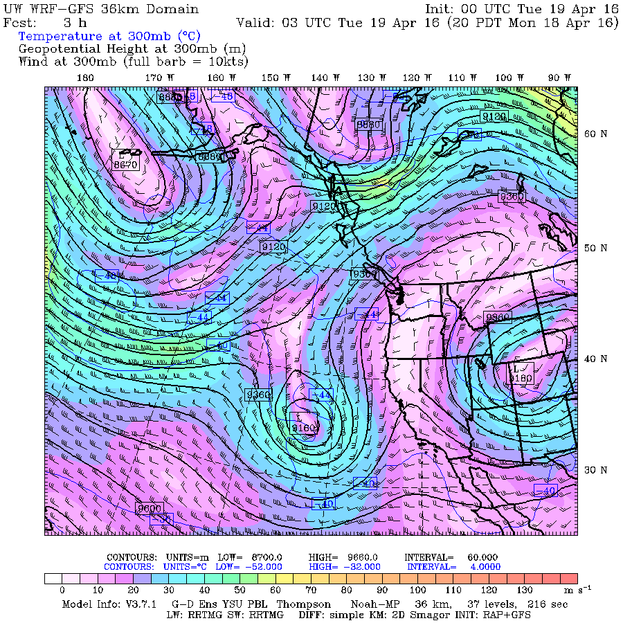
So why is this all happening, it boils down to the jetstream.

You can see the blue above of the jetstream flowing to the north parts of BC pumping in that hot air to Fort St. John and leaving a big open air to the south for hot air to fill in.
You should see the two swirls or eddies further south, one off California and one over the rockies. These will trap moisture and they will stay stationary, bringing torrential rain to wherever they affect most, in this case Houston. This is very much the same pattern that flooded Calgary in July of 2012.
We have seen huge temperature increases and a record low icepack in the Arctic this winter. Have those conditions created the possibility or increased the chances of this extreme weather? Personally, I think it is obvious. I am sure there will be teams of meteorologists and climatologists going over the data once again to find out just how strong the finger prints of climate change are on this weeks extreme weather.

