Perfect fishing weather approaching!
The fish are going to be feeling frisky this weekend as we have some cool weather and showers that will get them moving. Hold on tight to those lines!
Friday night Fireworks dry, but cool.
You might want to put on a sweatshirt tonight when you go down to Tree Landing and Harbour Quay to check out the fireworks. It’s probably going to feel pretty chilly and there might still be a breeze as well, but it’ll be perfect for fireworks so get down there early to get a spot!
Saturday early morning shower possible.
Some showers may come through overnight. There is a little finger of moisture reaching up the inlet in the 11PM-12AM timeframe.

And 12AM-1AM

But as you can see the model has the main band of precipitation coming ashore just to the south of Barkley Sound and the Alberni Inlet in the 1-2AM hour. It will be enough, however, to charge the rivers and streams a bit and send that cool water into the Inlet on Saturday and probably get the fish moving and hopefully hungry!

A smaller band of showers comes ashore near Ucluelet and northern parts of Barkley Sound in the 4-5AM hour.

The precipitation spreads into greater Barkley Sound after sunrise by 7AM.

The chance for showers in Barkley Sound and the Alberni Inlet will remain for the entire day on Saturday.
In Port Alberni we can expect a little stronger rain activity in the afternoon as it looks like there might be some unstable, convection air around, but probably not enough for a thunderstorm.
Sunday remains cool on the water but dry though possible afternoon mountain thundershower.
There is no significant precipitation on the models for Sunday now. There may be some very patchy showers along the hills particularly in the afternoon but other than that the model is clear for most of the Island.
Monday back to sun.
Labour Monday will be back to full sun and temperatures into the high twenties and will lead us into the same for the first week of September!
Extreme Fire Danger.
Please be careful if you’re in the backwoods. The PA Fire Department said it best so I’ll just leave it to them!
Also, they’re hiring!
Florida expecting landfall of a Major Hurricane as climate change has and will make strong hurricanes get stronger.
The Hurricane season has been pretty quiet on the East Coast of the USA but it’s peak season now and right on schedule there is a big Hurricane, and it’s headed for Florida.
As of yesterday, Hurricane Dorian was expected to “undergo a round of rapid intensification by Saturday, which will bring it to at least Category 3 strength as it approaches the Southeast U.S. coast on this weekend.“
And it looks like that is setting up now as the Hurricane expands and an eye forms this morning, from the 11AM ET forecast discussion:
In fact, the eye is becoming apparent on visible images as we speak and in radar data from the NOAA P3 aircraft. Consequently, the NHC forecast calls for additional intensification, and Dorian is expected to become an extremely dangerous major hurricane soon with additional strengthening likely as it heads for the northwestern Bahamas and the Florida peninsula.
Here’s the current track, there is still lots of uncertainty on where it will make landfall exactly.

Peak windspeed are currently forecast to get to 140mph/225kph.
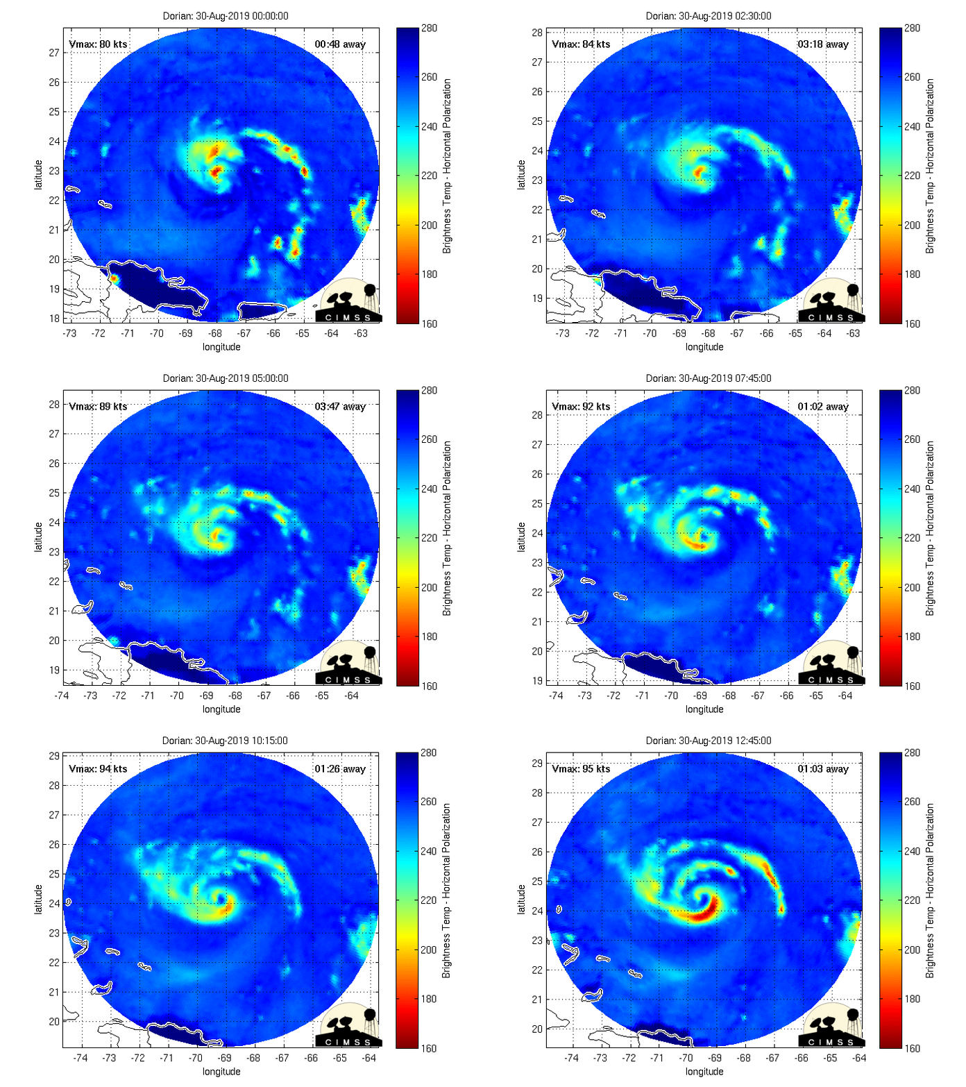
Here’s the Microwave imagery tracking the centre of the storm. You can see the eye forming. (The imagery is updated frequently. You can see it for any tropical hurricane/typhoon system here).

Finally, yes, there is a climate change connection. As world renowned Penn State Climate Scientist Dr. Michael Mann said this morning, “There is absolutely now a consensus that the strongest hurricanes will get stronger in a warmer world and that, indeed, they already have.”
In response to my question this morning Dr Mann provided a nice list of data on that question as well.
Here’s one study he provided:
Downscaling CMIP5 climate models shows increased tropical cyclone activity over the 21st century“
“The intensity of such storms, as measured by their maximum wind speeds, also increases, in agreement with previous results. “
And another one from Nature in 2008: “The increasing intensity of the strongest tropical cyclones“
Atlantic tropical cyclones are getting stronger on average, with a 30-year trend that has been related to an increase in ocean temperatures over the Atlantic Ocean and elsewhere1,2,3,4

