Showers off and on and cool for Halloween
Here’s the Podcast for this post!
The bad news is, it is going to start a little wet this morning. So if your goblins are headed to school in costume, I hope they had an umbrella and a warm jacket!
The good news is for the trick-or-treaters tonight it will feel pretty chilly and it might be a little damp but it looks like the threat of showers goes away before sundown! Bring an umbrella just in case though and definitely think about some extra warm socks and shirts!
Here’s an hour-by-hour forecast for Halloween in Port Alberni!
8AM – Lingering showers
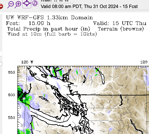
As you can see there are some lingering showers along the Beauforts and near the Alberni Valley this morning, but for the most part the rain has moved off the Island except for the West Coast this morning.
By Noon, the moisture has dried up and while it will probably stay cloudy all day, it should not rain!
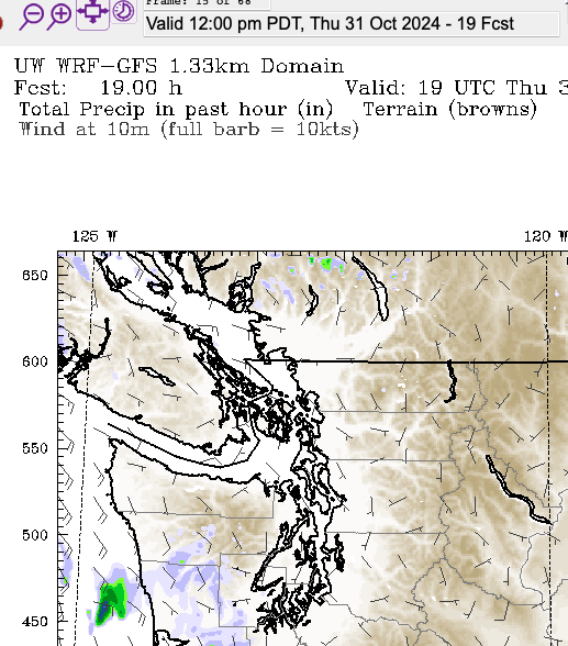
Some showers creep back onto the West Coast this afternoon around 4PM but the model says the rest of the Island will stay dry!
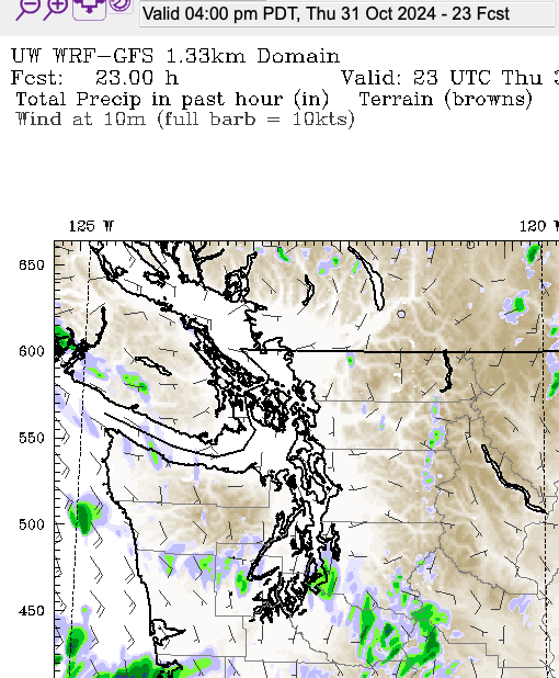
The later into the evening we go, the less chance of showers.
Have fun and be safe out there!
What is a Gota Fría?
If you’ve watched the news at all, or been on social media, you will have seen pictures coming out of southeast Spain as they deal with a catastrophic flooding from extreme bursts of rainfall in the mountains along the coast. A town about 70km east of Valencia in the foothills received over 400mm of rain in just 8 hours. For the region, that’s a year’s worth of rain.
The impacts have been devastating. You can see a thread I made yesterday on Mastodon with more information here:
The culprit, La Gota Fría: A Cold Drop
There are similarities to our own Atmospheric River flood events of November 2021, but the events are not exactly the same. In the news you might have seen “DANA“, in Spanish it’s “Gota Fría“, in French it’s “Goutte froide“, in English it’s a “Cold Drop”. I’ve been learning about this over the past day.
The graphic below is in Spanish, but you should be able to follow alone.
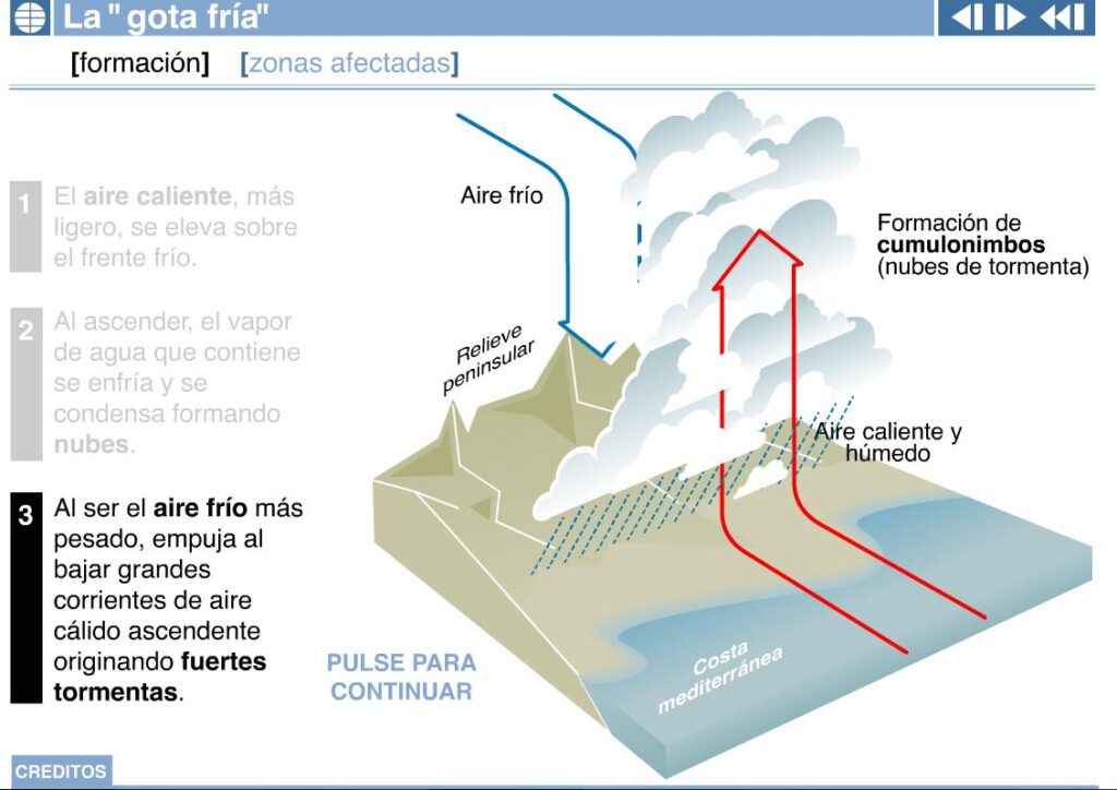
Step 1: The warm air laden with moisture comes in off the Mediterranean, and rises rapidly in front of a cold front caused by the cut off low pressure system.
Step 2, as it ascends, just like we see here when warm air comes in off the Pacific, it condenses and forms clouds.
Step 3 is what makes for the big events. The cold air from the front at the same time pushes down the side of the mountain causing a massive amount of convection, causes thunderstorms, and that’s what drops torrential rains!
It’s similar to our Atmospheric River events in that our mountain regions amplify the amount of rain that is dropped and then that water gets funnelled down to the Coast. There were also huge forest fires in 2012 in the mountains West of Valencia that may have caused the rains to funnel more quickly, like we had in 2021.
Over 400mm measured in Chiva in 8 Hours
The epicentre of the strongest rains seems to have been just west of Valencia in the foothills in a town called Chiva.
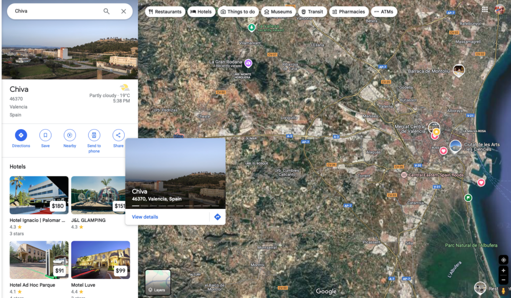
On Monday they received 400mm in just 8 hours. A years worth of rain. As you can see from the map above, Chiva (on the middle left) is directly west and upstream from Valencia. The Turia river runs through and around the City. Think of Chiva as Hope and Valencia as Vancouver and you’ll get the idea. While the Turia is not nearly as large as the Fraser River, it funnels most of the water from the region into the Sea.
According to climate scientists: “No doubt about it, these explosive downpours were intensified by climate change.” As the Atmosphere warms along with the waters of places like the Mediterranean, that provides much more moisture to these events and leads to more and more extreme rainfall totals and resulting floods. As we saw with the Hurricanes in the US this month, the intensity of the rainfall of storms around the world is rising with climate change and global warming.
Could this happen in Port Alberni
While we don’t have the very warm waters of the Mediterranean, we do have the combination of mountainous terrain and copious moisture coming in from the Pacific Ocean with our Atmospheric River events. We have certainly had flooding from intense rain storms, especially when it combined with high tides, but the Atmospheric River events and their intensity are a little newer.
We were lucky in November 2021 when the band of moisture missed us to the South. Next time, we might not be so lucky, if the rain fell mostly on the Central Island, Strathcona, and the Alberni Valley, then we could see our own version of flash flooding like we saw in the Fraser Valley and Cowichan Valley.
This is something we should prepare and plan for.
Have a great Halloween!

