Hi everyone,
The great weather continues! It’s really turned into a fantastic summer hasn’t it?! I hope you have been able to enjoy it!
This weekend we’ll be getting back into the 30s all the way out to Wednesday and possibly farther than that. It doesn’t look like we’ll get a break from this until around the 21st or 22nd, but even then there isn’t much to worry about and we should remain warm and sunny right through to the end of August.
Siberian Smoke is back.
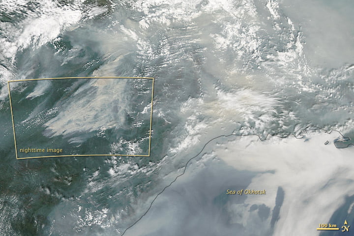
If you noticed the haze or smoke in the air yesterday and wondered if the Siberian fires were the cause you would be right. Once again the wind patterns over the Pacific have dragged the smoke all the way from Siberia and into BC and even Alberta!
Unfortunately the NASA MODIS satellite image of the day is offline right now so I can’t get an image of the smoke over us even though its their feature for August 11, but they highlighted the Siberian fires in their August 7th update so here’s the image from there:
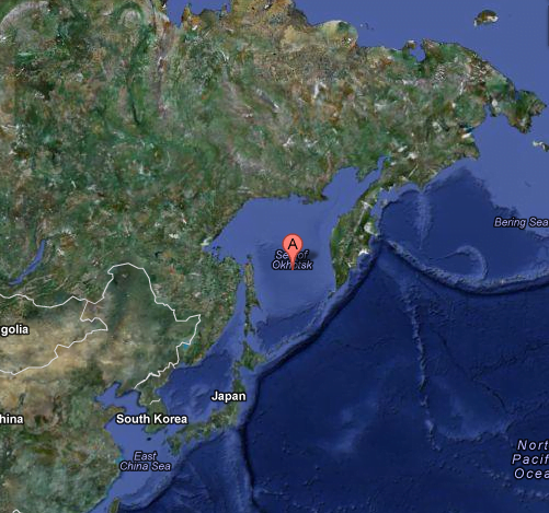
There is actually so much smoke that it’s difficult to tell where this is, but it’s near the Sea of Okhotsk on Siberian Pacific Coast north of Japan.
Arctic Storm
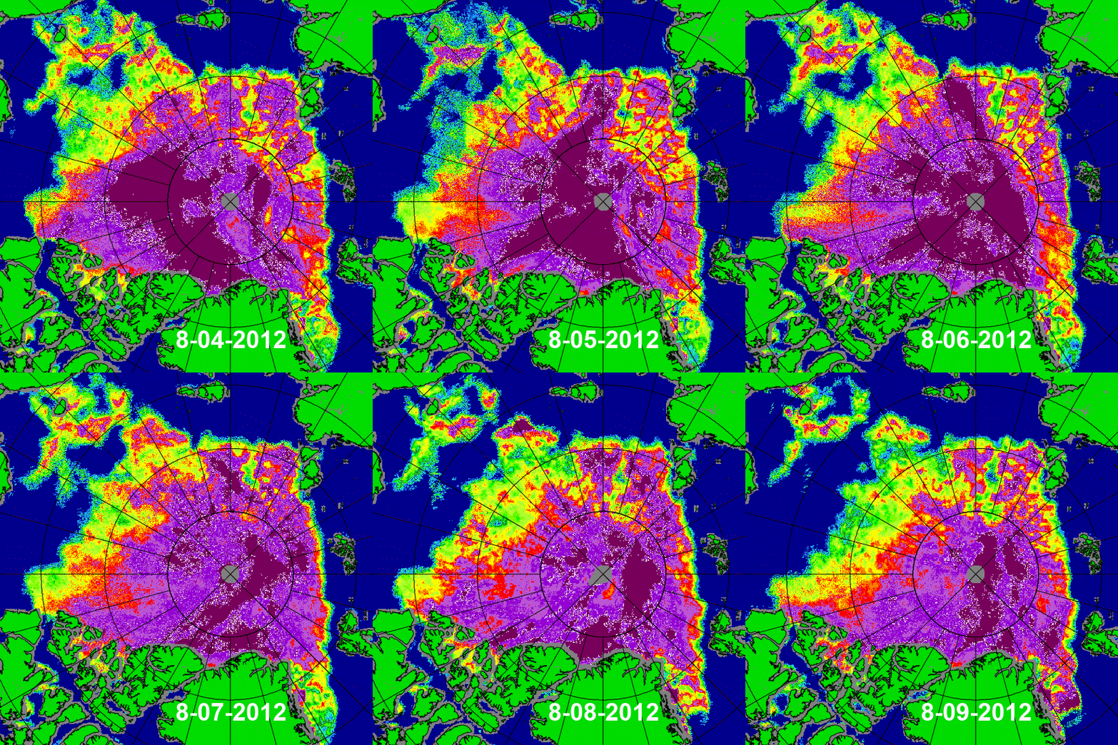
It’s really unfortunate that it hasn’t been covered, that I have seen, on any of the major news networks, but the massive Arctic Summer Storm has weakened now but it has left it’s mark on the Arctic. The sea ice up there was already trending to record lows, without any kind of severe weather pattern, before the storm. (So don’t let anyone else tell you otherwise). But this storm has been like the proverbial bull in a china shop.
Watch in this animation of the past few days during the storm how the ice gets pushed (the dark purple areas are the most solid, 100% coverage of ice) from West to East across the Arctic by the storm and a big chunk gets seperated and melts away near Siberia. Incredible imagery!
You gotta go see the Arctic Sea Ice Blog. He’s got some great analysis of it.
Here is the first image from August 4 and the latest image from today. (the imagery comes from the University of Bremen in Germany) The difference is stunning.
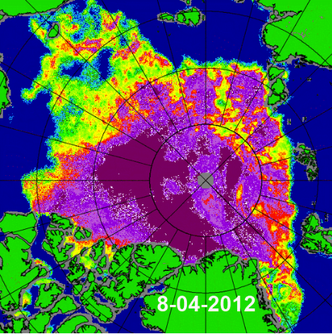
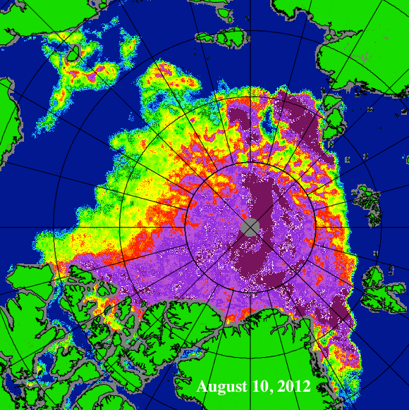
The edge of the more solid ‘pack ice’ (purple areas) moves from basically the 80th Parallel (the 2nd smallest circle) to the 85th Parallel (the smallest) from the Canadian side to the Russian side. That’s thousands of square kms of ice moving/melting more than 500km to the north. Notice the very-solid, 100% (deep purple) colouring is greatly reduced and there are patches of weak ice extending from the West right into the heart of the basin near the North Pole. This is in the span of 6 days and we still have 2 or 3 weeks left in the major melt season.
Meteor Shower and Stars and Moon!
This weekend is the annual Perseid Meteor Shower! The best nights will be Saturday/Sunday/Monday.
You can read and watch more about them on NASA’s website:
http://science.nasa.gov/science-news/science-at-nasa/2012/10aug_perseids/
There is going to be a beautiful crescent moon interacting with the planets Jupiter, Venus as well so get out in a nice dark spot and look for those meteors! The peak is on Sunday night you should see many meteors an hour.
And if you’d like to help scientists keep track of the meteor showers intensity, the website above has a link to a Meteor Counter app for iPhone/iPad and Android! Cool!
I also just found out that August 31st will be a blue moon (the second full moon in the same calendar month)! What a month!

