California currently in crisis.
North and Central California are in the midst of an Atmospheric River event that will seem very familiar to anyone who lived through the AR events here in BC and the Pacific Northwest.
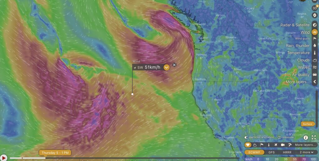
Well, it looks like this time the firehose has been pointed a little further south. Look at that beast! Below is a model forecast for the current time around 12PM Wednesday.

The main feature here is going to be that absolutely gigantic amount of moisture to the southwest that is being swung toward South Oregon down to the San Fransisco Bay Area (but also some remnants to LA and points south). BC is going to get the aftermath of those bands and fronts as they move up and the low gets closer to the continent.
By Thursday we’ll start to get very windy and very wet, as the first low approaches Vancouver Island while another storm takes aim at California.

In fact, this is just the beginning of what appears to be a long train of weather and rain systems that will be impacting nearly the entire west coast of North America over the next weeks. Below is the picture for a week from today. More of the same.

200mm of Rain near San Fransisco
The 16day forecast at SpotX for just north of San Fransisco predicts 230mm of rain between now and Saturday.


That is an incredible amount of rain normally for that area but especially for a place that has been in a state of serious drought for number of years.
Local Wind and Rain
The first low will pass Vancouver Island on Thursday evening. Below we can see it off the coast, it will move almost directly north and may not even make direct impact with the Island but it will swing strong winds and rain our way.

Rain will begin Wednesday night but the main force of the first wave to hit Vancouver Island will be through Thursday night as the approaches and Friday. From Thursday 4PM to Friday 4PM the model expects 25-75mm in Port Alberni and on the West Coast as we can see below.


Wave after wave
- Expect Rain:
- Wednesday overnight
- Thursday (afternoon and night)
- Friday (all day/night)
- Saturday (morning)
- Sunday (afternoon)
- Monday all day/night
- Next Wednesday night
At this point, Friday and Monday look the strongest for both rain and wind. But whatever we get here, think of it like just a taste of what they will be receiving a few hours ahead of us in the USA.
Western North America is getting wet this week.

