“Most of the heavy showers have moved out of the region.” Special weather statement ended.
I’m back! 🙂
Tons of unstable air and moisture out there has prompted a special weather statement from Environment Canada.
10:52 AM PDT Sunday 26 July 2015
Special weather statement in effect for:
- Inland Vancouver Island
Brief heavy downpours and small hail likely today.
A cool upper trough has descended upon the South Coast early this morning. This unstable weather system will generate local heavy downpours of 15 to 25 mm per hour throughout the day. Isolated thunderstorms producing small (pea sized) hail are also possible this afternoon.
The public is advised to monitor future forecasts as warnings may be required
The activity is all over the place on the models, so it is hard to pin down where these thundershowers will be. So you will simply have to be prepared for all or nothing through the morning and early afternoon.
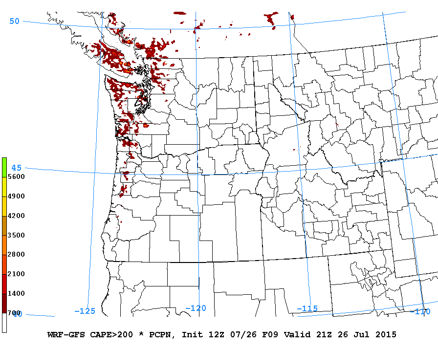
Here is the lightning/thunder map from the model showing chances all over the Island for thundering. 🙂
The chances for rain fades and pulls back to the hills by evening.
Focused on us on Monday.
It will mostly dry out Monday, however, there is a strange little patch of rain right on top of us Monday afternoon.
This might be thundershower type activity but there is no such chance on the model so probably just spotty rain.
We should be completely dry by Tuesday and warming into the mid-to-high twenties again and higher through the end of the week.
Wildfire ratings knocked down for now.
The good news is that even though we are still at High, the fire danger rating for the whole province has taken a much different tone at least at this moment.
Long range looking dry and hot again.
The super long range forecasts have us returning to a dry and hot pattern through the first week of August.
Have a great Sunday!


Comments
2 responses to “Chance of Thundershowers Sunday – Gradually returning to Hot and Dry”
Hey Chris, I hope you enjoyed Oregon…one of my favourite places . I posted this on alberni.ca but I thought I would put it here for your opinion. I have never truly understood how El Nino drives the weather but I am getting a grasp on it. Am I correct in thinking that the biggest concern for the changing climate is the fluctuation in ocean temperatures?
http://www.thrillist.com/news/nation/new-el-ni-o-photo-should-scare-the-shit-out-of-the-west-coast
Thanks Tom! Definitely a stunning picture of just how warm the Pacific has become. The interesting part will be to see what scientists pin down as part of El Niño and what part will be the PDO and what part is global warming. The overriding fact here is that due simply to the surface area it covers and the properties of water itself, the Oceans are absorbing the vast majority of the additional energy being radiated back from GHGs in the atmosphere. How that energy is released (much more slowly than it would be if only land was involved, again as we know commonly from the properties of water) into the global climate system, and how it interacts with or disrupts natural cycles like El Niño and PDO, and is the great unknown that I doubt our current climate models can truly grasp. But the basic laws of thermodynamics tell us energy is never destroyed, only transferred. So we are feeding a heck of a lot of energy into a very complex and powerful system. Results will surely be dramatic at times.