Over the past couple days anyone paying attention to a number of weather forecasts would have noticed some inconsistencies with this weeks forecast, especially later in the week.
Environment Canada had originally been calling for no chance of snow at all, while other models have consistently suggested some sort of late week cold that could bring us snow.
Well, with the frost yesterday and the even colder temperatures this morning… the shoe has dropped and so has the forecast. Expect a chance of flurries tonight and tomorrow morning. Nothing serious, no major accumulations, but there could be snow on the Hump and Sutton Pass.
But that’s not all. The GFS models especially and other forecasting sources at Accuweather here and here are calling for a possible repeat this Thursday of the northerly storm we got last Friday followed by a shot of quite cold weather.
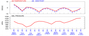
The best illustration so far is the GFS Model:
Here is the short term week. (click for larger) The precipitation (not shown) is not huge, just flurries. With the exception of the very last day of the forecast, Monday, which has a major shot coming but with temperatures in the 3-4C range, so a possibility of snow changing to rain on Monday.
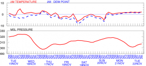
But the really impressive one is the long range. Which show consistent cold *plus* significant significant precipitation. This is potentially a real snow maker!
Here’s the Temperatures (top, horiz line is 0C) and pressures.

Here is the Precipitation over that period. All I can say is… Uhoh! 🙂


Comments
3 responses to “Has the Snow shoe finally dropped?”
Very interesting!
YAY!!! I love this time of year!!! I’ll get my snow plow on the quad asap 🙂
It’s snowing downtown – started a few minutes ago.