UPDATED 5:30PM – Rain stalled.
Sounds like Tseshaht currently has enough bags and help! I will update if more is needed!
The rainfall warning is continued. The rain has stalled over us and will take longer to taper off. Not good for flooding areas.
There is currently an evacuation and sandbagging effort happening right now on the Tseshaht reserve area. Sandbagging is being directed from the Tseshaht Admin building.
Highway 4 is closed in both directions due to floodig at Hector Road. There is a detour through McCoy Lake road. Please be very careful in all areas as all areas with any standing water are at capacity.
The City of Port Alberni and ACRD have opened their Emergency Operations Centre. They just put out the following status report
• Multiple downed power line events for hydro and fire crews – ongoing.
• The river systems are rising, especially in the Ferguson Road area / Hector Road; with one house flooded and river bank breached. – Beaver Creek Fire Department and AVRS are
• Water distribution systems are stable at this point.
• Highway 4 has seen temporary closures due to flooding (Watty’s Hill) Traffic is currently unable to get through. Emcon is sourcing out an alternate route..likely through the logging road system. There are no issues with any bridges at this point.
• Lower Hector Road is closed.
• Works crews are busy clearing roads from trees and debris.
• Tseshaht First Nations is evacuating homes along the Somas River. ESS is finding alternate accommodation.
Stay safe out there folks and help if you can.
The tide is peaking right now but it will take some time for the river levels to go down and the waters to recede.
MAJOR FLOODING HECTOR ROAD/HIGHWAY 4
There is major flooding on Hector Road. As the rain is still falling, the wind still stiff and the tide rising, I would expect this to not get better soon.
Please be careful. You should not drive through these kinds of floods since you cannot tell how deep they are, and you might be causing waves that will make more problems for businesses or residents.

9AM update:
In point form for quickness:
- We are slightly behind pace of rain from yesterday (to 8:40AM 42mm vs. 48mm yesterday)
- Rainfall warning still in effect
- Tide is just passed the low for the morning (8:27AM). High is 2:21PM at just over 10ft.
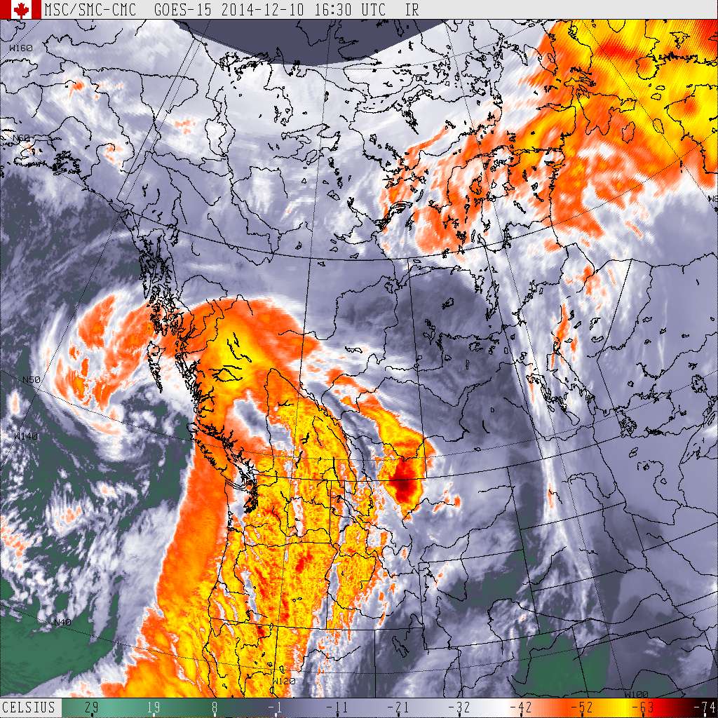
- There have been some gusts but nothing like yesterday so far but the barometer is still falling and satellite imagery (below) shows the backside of the front is just now hitting north Vancouver Island.
-

The back and potentially windiest part of the front was just crossing the top end of North VI at 8:30AM in this image. - We should expect this rain to continue for at least the next 2-4 hours. The UWash model shows the back of the front over us in the 10-11AM hour. That means we should expect the rivers to continue to rise at least until then and for highest winds to be then.
-

11AM for previous hour shows back side of front directly lined up with the Alberni inlet. This should be the period of highest winds and last gasp of highest rain. - Expect showers to continue all day even after the front has passed.
- Our highest rain rate today has been 27.9mm/hr. Yesterday’s was “only” 17mm/hr.
- The River Forecast Centre has issued a High Streamflow Advisory for all our major Alberni Valley rivers. (Stamp, Ash, Sproat, Taylor)
- I’ve fixed some of the issues with the daily rain values not showing up but am still working on the high wind speed values. It was showing the high sustained wind speed before, not the highest gust, so am working on that.
Looking at the night run of the model I thought to look at the comparison on wind gusts between the prediction for Tuesday compared to Wednesday morning.


Unfortunately, given this it looks as though there is potential at least for stronger winds even if the rain is not as severe. However no warnings have been issued for wind and it is notoriously hard to predict what will actually make its way up the Inlet. The rain doesn’t look to have shifted any closer to high tide though, so hopefully that holds.
Have a good and safe sleep all. I know I need some!
Official ACRD warning of wind, rain, river problems.
December 9, 2014, 3:30 pm
This notice is provided as an alert for the possibility for heavy rains, strong winds and high water flows in the Alberni Clayoquot Regional District
Weather in the Alberni Clayoquot Regional District over the next 24 hours is likely to be a repeat of the last 24 hours, in which areas of the region received strong localized winds and rainfall ranging from 90mm (Beaver Creek), 115 mm (Alberni Valley) and 241 mm (Kennedy Lake).
Warm and extremely moist air from the sub-tropics is being directed towards south-west British Columbia. Heavy rainfall and rising temperatures are expected with this system. Several episodes of heavy rain are expected throughout the week, with the second round of rainfall occurring Tuesday evening through Wednesday morning. Heavy rainfall warnings from Environment Canada continue to be in effect, with 100-200mm of rain forecast for areas of West Vancouver Island and Central Vancouver Island and 25-100mm or more for other areas.
Rivers are expected to rise in response to the rainfall overnight on Tuesday adding to already high conditions, with rapid rises in levels expected into late Wednesday.
This current atmospheric pattern is expected to persist throughout the week. With saturated soils and strong localized winds the threat of wind fallen trees will increase.
Rainfall events of this nature can trigger high turbidity in community water supplies with the possibility of a boil water advisory. Notification will be provided but in the meantime, please conserve water. The following additional advice is provided:
- Ensure that the drains on your property are clear and unlikely to clog.
- Stay away from water courses as flows may surge and can be dangerous.
- Those living in low lying areas along streams and rivers should be extra cautious.
- Prepare for the possibility of power outages.
- Limit water use.
Russell Dyson, Chief Administrative Officer
Alberni Clayoquot Regional District
office: (250) 720-2705
cell: (250) 720-7051C.A. (Chris) Jancowski, B.FSS, CFO, MIFireE
Deputy Fire Chief
Port Alberni Fire Department
T: 250-724-1351
DECEMBER 9 TEMPERATURE RECORD SMASHED
An incredible high at the Airport was reached: 14.5ºC
The next closest was 12.2ºC at city of Port Alberni in 1921 and 1957. This record goes back to 1900 across all stations with at least 30years of data and all the ones of record, Beaver Creek, City of Port Alberni, Robertson Creek, Port Alberni “A” and the new Airport automated station. This also beat the record for the entire month of December at Robertson Creek but not at Somass “A”. Previous was 14.0ºC and 15.6ºC in 1976 at Robertson Creek/Somass “A” respectively.
December 8:
Not record setting… We *just* missed an all time record high for the day on December 8 (Monday). We reached 12.1ºC at the Airport. The record at Beaver Creek, and Port Alberni City in 1938, 1939 and 1957 was 12.2ºC. We smashed the Robertson Creek and Port Alberni “A” (Somass) record in 1979 of 9.5ºC and 11.7ºC respectively.
More from today….
Round 1 delivered 107mm of rain. 47.8mm on Monday and the rest Tuesday.

You might notice there is a problem with the “Day’s Rain” value. I’m not sure what’s happening there. It’s bugging me! I will try to fix it tonight but I will keep you informed on the data either way. I have the raw data at my home station of course so I can check it there.
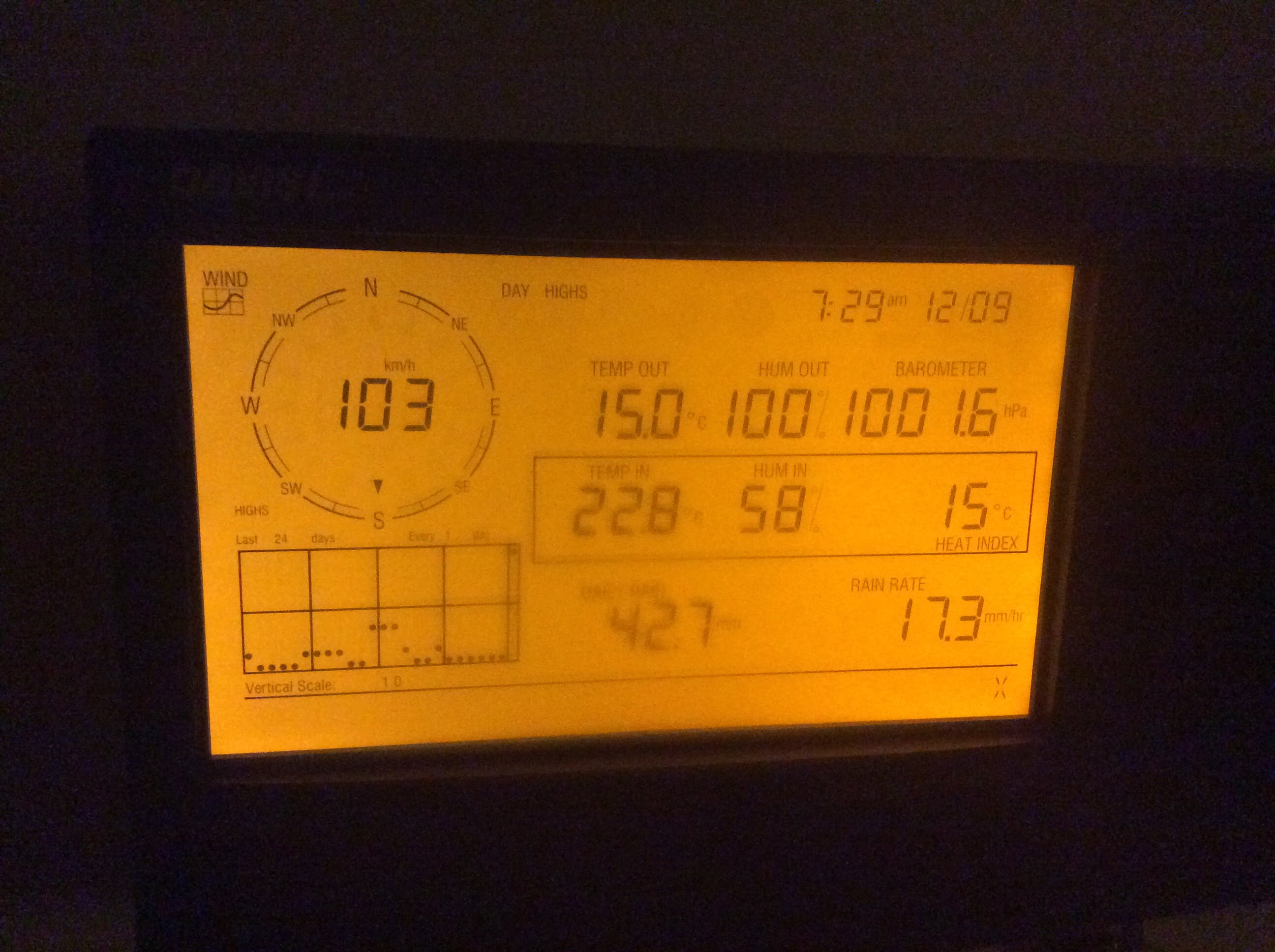
Here is the full 5min-by-5min report for the day. It shows the 103kph gust in the 7:35AM report. It also shows the consistent gusts over 60kph between 10:30AM and 12:30PM with peaks of 79 and 77kph. You can always find these daily reports (going all the way back to 2005!) at http://www.alberniweather.ca/Archive
That was 1 of 3. Fun yes?
A Rain warning has been issued again.
First, my apologies. As fate has it, I was in a council training session all day and so wasn’t as on top of things as I like to be, but it’s all good. 🙂
But no rest for the wicked we have more coming!
Next System Starts 4AM:

The good news is the models are not as aggressive. UWash says:

- The LAM says 70mm
- GEM says 60mm
- GFS says 60mm
- CMC says 90mm
So this is significantly less than Monday night/Tuesday morning. However, now that the ground is saturated and the waters are already high with runoff, a quick 2nd punch could cause problems.
Tides are a Problem:
We got very lucky today with the heaviest rain and wind hitting almost exactly at low tide…. tomorrows event may not be as lucky.
The next few tides are as follows:

The highest tide is just over 10ft at 2:21PM Wednesday. The tail end of the front tomorrow is supposed to still be strong in the 11AM hour as you can see below.

This isn’t quite at high tide, but it will take time for the rivers to respond and and stop building.
WIND
As for wind, I will be blunt. I think Environment Canada totally dropped the ball on the wind forecast but I sympathize with them because there were no models predicting that kind of wind for our area that I know of. There was certainly no warning for this.

Strong winds are just too hard to predict in our quiet little Valley.
There is potential for the same tomorrow morning in the 7-10AM hour. Beware.
Pictures and Video!
We had no power at Alberniweather HQ for a couple hours this afternoon due to a blown transformer. We rarely lose power! Many many others lost power in town and on the Island.
And finally, I will leave you with some pictures from around town of the havoc caused by the 1st wave December storm of 2014. There is another one coming on Thursday!
The moment of the highest wind gust this morning!


And here’s more from Global News:
PHOTOS: Port Alberni flooding closing roads, winds causing power outages


Comments
4 responses to “Update 5:30PM Wednesday – EVACUATION ON TSESHAHT – RAIN STALLED”
I looked at all those models too, and I’m hoping it’s not as big as this morning, but just by the size of that huge blob of orange coming at us on the EC satellite, this looks pretty big!
It does!
After reading this I’m guessing we should assume that River Road is going to flood out? It was 3′ from the road this morning at 8:15… I know it’s hard to predict, but how certain do you think?
Very hard to predict but I would say it is possible if we get another pulse of rain and a strong bit of wind in the next couple hours.