Alberniweather and Port Alberni Summary for November and Fall/Autumn 2023
Story of the Month – High Winds but only half the rain.
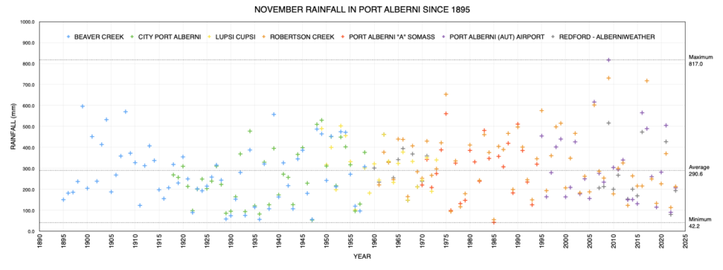
It’s not unusual that we see our first major windstorm of the fall/winter in early November and this month delivered a good one on November 4th. Alberniweather recorded a gust of 74kph. One of the highest in this station’s records. I happened to be home that day and there was a noticeable “thump” on the side of the house as the gust hit! That storm also delivered the vast majority of the rain for the month. From then on, it was very quiet and as a result, we ended the month with just 60% of our normal total of precipitation for the month. It may not feel like it, but the rain (and snow) deficit continues.
We’ll see this in the annual totals next month. As of November 30th the Airport has received 1201.4 mm of rain. The normal for a year is 1910.7 mm of precipitation (1797.9 mm falling as rain). We are 700mm behind that total.
This Month’s Timelapse
Now that the webcam is fully up and running I can introduce a new feature to these summaries! A monthly timelapse in full 4K video glory! I am very happy with it. It also includes a music soundtrack.
I’ve created a Youtube Playlist for Monthly Timelapses so they are easy to find. I’ve also added the partial month timelapse collected in October to the October Summary. And of course, you can check out the live webcam here and daily and hourly timelapses.
Story of the Fall 2023 Season – Dry and Warm
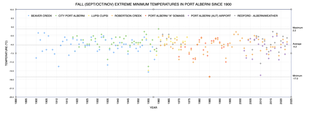
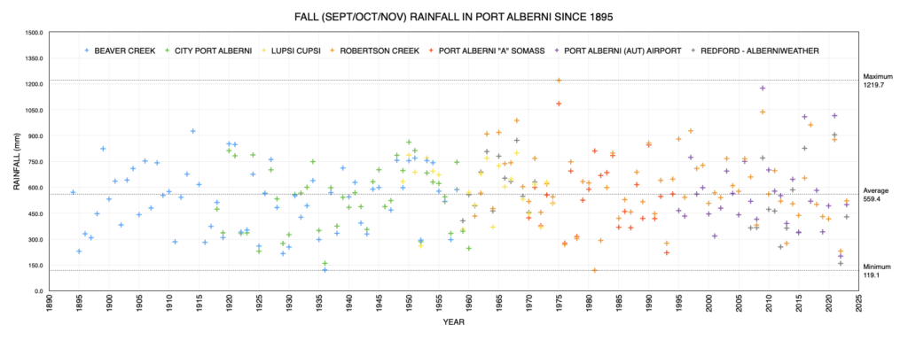
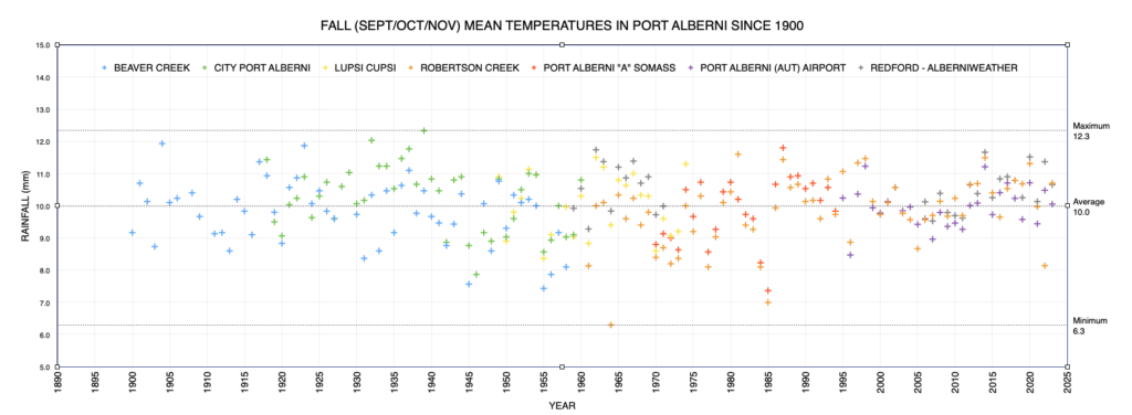
It should come as no surprise that if you look at the graphs below for the autumn season compared to the historical record, temperatures were generally higher than the average and rainfall was below average.
500mm (actually 499.7) for the Fall season might sound like a lot of rain but not when you consider 345mm is our normal for November alone (Robertson Creek 1971-2000). Adding up September, October and November normal precipitation gives us 628.7mm as the normal fall amount. 500mm is 79% of that. As already mentioned, we have a very large deficit for the year.
Ocean Conditions and El Niño – Moderating?
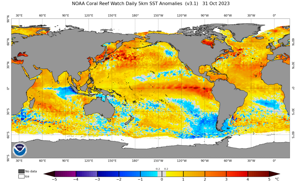
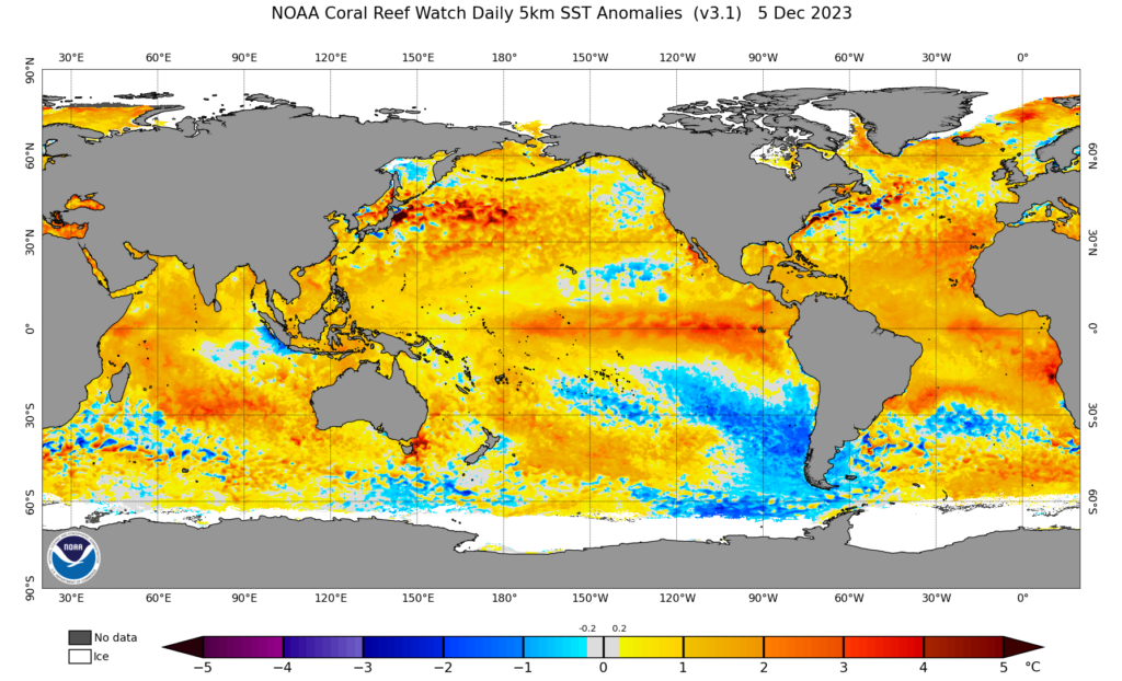
Switching over to oceans. The current image of the Oceans Tempreature Anomalies from Dec 5, 2023 show a few interesting changes in the North and South Pacific compared to the last time we looked on October 31. I’ll keep the earlier image first below.
What stands out to me is the cold patch of water off the west coast of Canada has dispersed and seems to be weakening. The same for the cold areas that seemed to stretch from Baja California to Hawaii. However, in general it looks like the waters of the NE Pacific (between Alaska, Hawaii and the West Coast) have generally moderated. There seem to be less areas of very high temperature as well as very low.
In contrast, in the southern hemisphere, the band of cold water off the coast of South America has deepened noticeably. The El Niño band seems to have tapered off.
What does it all mean? Perhaps a little less energy/heat in the Pacific Ocean system, so less likelihood of extreme heat, or extreme rainfall? I’m not confident in any of that but it is very interesting to watch.
Records and other Thoughts – (What Records?)
Probably one of the most odd aspects of this month was the lack of records set at the Airport. Just one day set a new record for the Airport (1995-current) on November 4 when the strong winds brought in lots of warm air and got us to 15.9ºC. It wasn’t even close to an all-time high though, and that it was it. With days of calm and foggy weather for the rest of the month no other temperature or rain records were set. A quiet month in that respect.
That’s all for this summary. Enjoy the data and charts below!
Airport Daily Records Set this Month
Set at Airport* since 1994 and compared to Valley stations** for all time.
(since 1895 for rain, 1900 for temperatures, 1980 for snow on ground)
Just one record set at the Airport this month. A high temperature. It may also be worth noting that Robertson Creek had a maximum of 16.5ºC on November 4 which is higher than the monthly extreme in the 1970-2000 climate period of 16.1ºC set on Nov 3, 1973 but higher values have been set since then. Unfortunately, the data from Robertson Creek was incomplete with 4 days missing.
- November 4 – High Temp 15.9º C at Airport. All Time is 19.0º C at Robertson Creek in 2019.
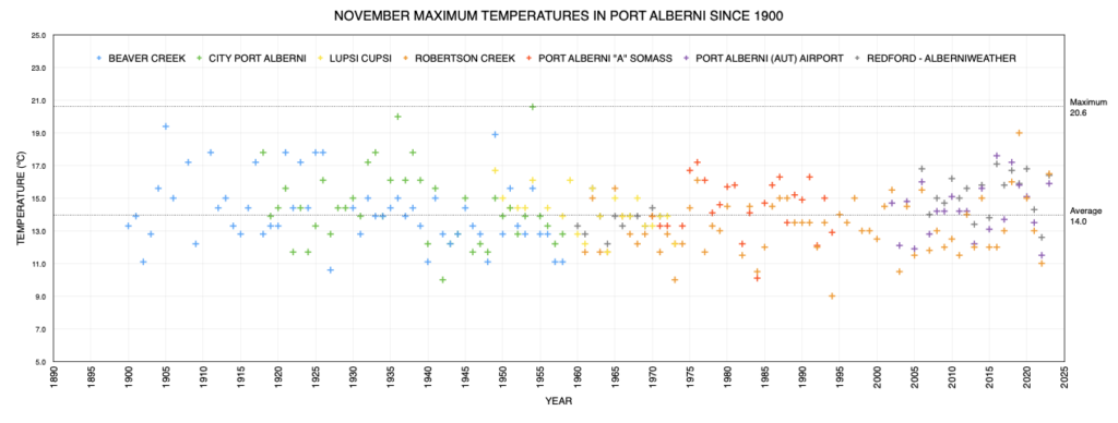
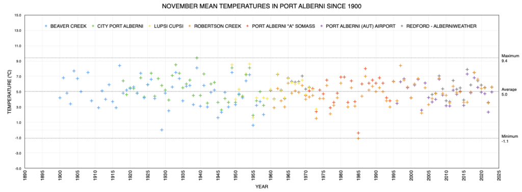
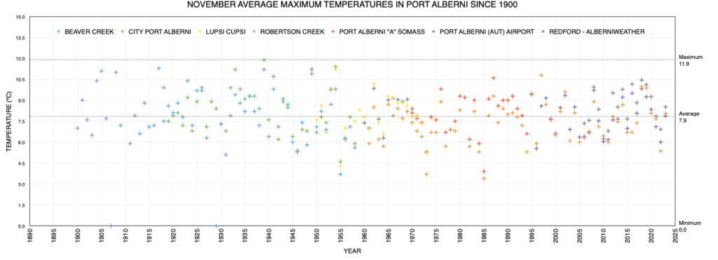
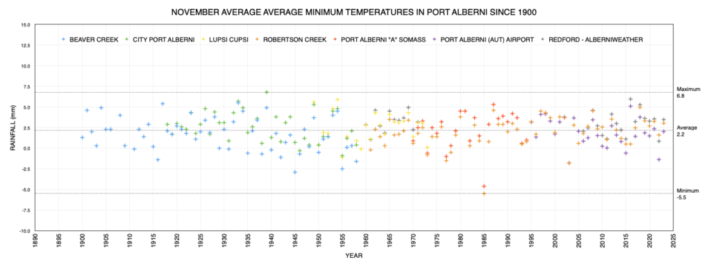
November and Autumn Graphs from Historic Alberni Valley Weather Stations
Combining Environment Canada and other Personal Weather Stations
Latest values on the far right, click to enlarge/download.
This Month’s City Values Compared to Normal
Please shift your phone to landscape/horizontal to see the table.
| Extreme (ºC) | Average (ºC) | (mm) | Wind (kph) | ||||||
|---|---|---|---|---|---|---|---|---|---|
| Location | Max | Min | Min | Mean | Max | Rain | Dir | Speed | Day |
| Alberniweather | 16.4 | -0.5 | 3.5 | 5.6 | 8.5 | 193.5 | ESE | 74.0 | 04 |
| Dave’s (Uptown) | 15.4 | -1.0 | 3.4 | 5.4 | 8.2 | 301.7 | NA | NA | NA |
| Nick’s (South Port) | 15.0 | -0.7 | 3.5 | 5.3 | 7.5 | 175.6 | NA | NA | NA |
| Kitsuksis (North Port) | 16.5 | -0.4 | 3.1 | 5.4 | 8.7 | 253.8 | NA | NA | NA |
| Alberni Elem | NA | NA | NA | NA | NA | NA | NA | NA | NA |
| Maquinna Elem | NA | NA | NA | NA | NA | NA | NA | NA | NA |
| Extreme (ºC) | Average (ºC) | Average (mm) | Ext. Wind (kph) | ||||||
| Max | Min | Min | Mean | Max | Rain | Dir | Speed | Day | |
| Combined City | 16.5 | -0.5 | 3.4 | 5.4 | 8.2 | 231.2 | ESE | 74.0 | 4 |
| Normal (Somass) 1971-2000 |
2.2 | 5.1 | 7.9 | 297.7 | |||||
| Difference from Normal | +2.0 | +0.5 | +1.0 | +2.5 (101%) |
|||||
|
Extreme Day |
17.2 | -16.8 | 90.1 | 43 | |||||
| Max | Min | Min | Mean | Max | Rain (mm) | Dir | Speed | Day | |
| Extreme (ºC) | Average (ºC) | Wind (kph) | |||||||
| Days of Rain | >=0.2 mm | >=5 mm | >=10 mm | >=25 mm | |||||
| Normal | 20.1 | 12.7 | 9.6 | 4.0 | |||||
| This Month (Alberniweather) |
19 | 12 | 6 | 2 | |||||
Official Airport and Robertson Creek Environment Canada Stations Compared to Normal
Please shift your phone to landscape/horizontal to see the table.
| Extreme (ºC) | Average (ºC) | (mm) | Wind (kph) | ||||||
|---|---|---|---|---|---|---|---|---|---|
| Location | Max | Min | Min | Mean | Max | Precip | Dir | Speed | Day |
| 15.9 | -1.3 | 2.0 | 4.9 | 7.9 | 206.9 | SE | 40 | 9 | |
|
Robertson Creek |
16.5 | -1.0 | 3.0 | 5.6 | 8.1 | 213.0 | NA | ||
| Normal (Robertson Creek) 1971-2000 |
1.6 | 4.3 | 7.0 | 345.0 | |||||
| Difference from Normal (from Airport) |
+0.4 | +0.6 | +0.9 | -138.1 (60%) |
|||||
|
Extreme Day |
16.1 | -17.0 | 103.2 | NA | |||||
| Max | Min | Min | Mean | Max | Rain (mm) | Dir | Speed | Day | |
| *New Extreme for Month | |||||||||
| Days of Precipitation | >=0.2 mm | >=5 mm | >=10 mm | >=25 mm | |||||
| Normal | 21.2 | 13.8 | 10.7 | 5.0 | |||||
| This Month (Airport) |
18 | 11 | 9 | 2 | |||||
This Fall’s Values Compared to Normal
Please shift your phone to landscape/horizontal to see the table.
These values are compiled in my own spreadsheet containing all ECCC stations data.
| Extreme (ºC) | Average (ºC) | Total (mm) | |||||||
|---|---|---|---|---|---|---|---|---|---|
| Location | Max | Min | Min | Mean | Max | Rain | |||
| Port Alberni Airport | 32.6 | -3.9 | 5.1 | 10.1 | 15.0 | 499.7 | |||
| Alberniweather | 34.4 | -1.4 | 6.9 | 10.7 | 15.3 | 429.0 | |||
| Extreme (ºC) | Average (ºC) | Average (mm) | Ext. Wind (kph) | ||||||
| Max | Min | Min | Mean | Max | Precipitation | Dir | Speed | Day | |
| Normal (Robertson Creek) 1971-2000 |
4.8 | 9.7 | 14.5 | 628.7 | |||||
| Difference from Normal (Airport) | +0.3 | +0.4 | +0.5 | -129.0 (79.5%) |
|||||
|
Extreme Day |
37.0 | -17.0 | 124.0 | 43 | |||||
| Max | Min | Min | Mean | Max | Precipitation (mm) | Dir | Speed | Day | |
| Extreme (ºC) | Average (ºC) | Wind (kph) | |||||||
| Days of Precipitation | >=0.2 mm | >=5 mm | >=10 mm | >=25 mm | |||||
| Normal | 48.5 | 26.6 | 19.0 | 8.6 | |||||
| This Month (Airport) |
42 | 27 | 18 | 4 | |||||
* May have used backup Environment Canada Data source at WeatherStats.ca for Missing Data
** Short Term means since 1994 at the new AVRA Airport. Airport Records are compared to the 30+ year weather stations of record since 1900 (1895 for rain) at Beaver Creek, Port Alberni “City” and Robertson Creek. Note that records pre 1950 may be more likely to over-estimate high temperatures.






Comments
One response to “November and Fall 2023 Summary – A Big Rain Deficit Continues – Monthly Timelapse”