So the models have held strong and are still predicting pretty significant snowfall over the next 48 hours starting with light flurries before sunrise Tuesday morning.
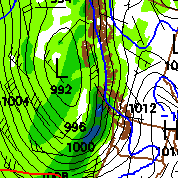
Here is the GFS for 10AM Tuesday. This is about the earliest that we can expect the first serious snowfall to start up. As you can see in the image, Victoria isn’t yet covered.

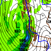
By 1PM things are really happening:

Notice also that the blue line has pulled oh-so-slightly to the East. Indicating that we are just above freezing. We really will be right on the borderline. Local area geography will be a deciding factor on whether this is a major snow or rain event.
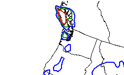
That said the updated snowfall probabilities show a 70% chance of us receiving up to 4 inches (10cm) before 4PM Tuesday.

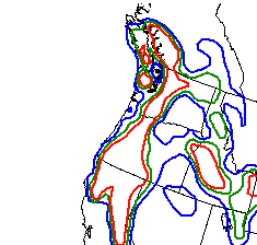
It shows a somewhat less defined 40-70% chance of another 4 inches (10cm) falling between 4PM Tuesday and 4PM Wednesday.

MAXIMUM: 8 inches will fall between now and Wednesday Afternoon.
MINIMUM: It will all be wet snow and rain with nothing on the ground except at higher elevations (skiers)
I think it will be somewhere in between those two. I wouldn’t be surprised if we had 5cm by noon tomorrow and then got into a really messy, slushy, yucky downpour for the rest of the day.
Good luck out there! I’ll update again tomorrow before 6AM.

Comments
3 responses to “Snow Forecast for Tuesday/Wednesday”
No doubt about waking up tomorrow morning early. It should be interesting. If you want a few more images for whatever purposes, feel free to snag stuff off my site. The NOAA APT images have been decent recently. 530am should be the last of the good morning updates tomorrow, and then nothing until just after lunch when the afternoon passes go again.
Awesome thanks Nick. Should be interesting tomorrow!
Huh, snow just in time for me to go back to work. Oh well, I have a 4×4, so getting to work and home should be fine, IF we get any snow, that is. Otherwise, it’ll probably be rain, as usual.