The Air Quality Advisory has ended but the 15km Burn Ban remains in effect.
It is cold again in Port Alberni, but if you are in the City you are only just feeling it now! There has been a surprising difference in temperature between the Valley (Airport) and City of Port Alberni most of last night and into this morning that then suddenly changed.
Here is the Airport over the past 24hrs.
Notice it has been nearly -10°C since 9PM last night and the humidity has not changed at all.
Now look at the Alberniweather station:
The temperature was just 0 as late as 6AM this morning and then dropped suddenly.
I checked the Alberni Elementary station to see if it was just something weird on my station and the same phenomenon appeared.
The graphs for my station don’t include Humidity for some reasons (will have to work on that) but the Alberni Elementary station shows that the temperature dropped at the same time as the humidity went up from around 50-60% to 90%.
What is the explanation for this switch? I am honestly not sure. Maybe I will be able to find out with others around the weather world.
Possible Snow starting Friday morning
The thing we are all watching for is what happens when this cold snap inevitably lifts and moisture comes in from the Pacific.
That looks set to happen starting Friday morning as a weak bit of moisture drifts down from the North island, reaching us between 4-7AM on Friday morning.
This is likely to be light snow at best but also the most likely to stay cold, and thus snowy. It is expected to have a threat of snow most of the day Friday and pull away from the area by Friday night.
A more significant system is expected to arrive midday Saturday.
It will spread rain or snow across the island Saturday afternoon, be most intense in the evening and night and then linger through all of Sunday.
How much falls as snow or rain will be completely dependant on local conditions, cold air pockets, elevation, etc.
At this point the Environment Canada forecast seems to be leaning more toward snow.
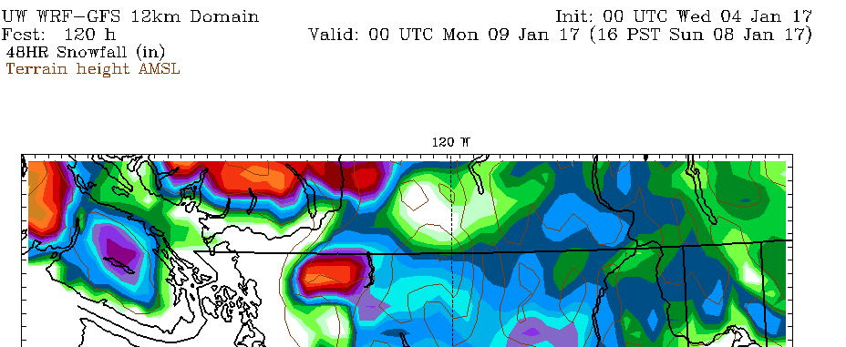
The UWash forecast however has a little pocket in the Alberni Valley for the 48 hours on the weekend showing very little snowfall.
No matter what, be prepared for treacherous and very changeable driving conditions if you are on the highway Friday, Saturday and Sunday.
We’ll see where this forecast goes by Friday morning!
Happy Wednesday!
The Air Quality Advisory has ended but the 15km Burn Ban remains in effect.


Comments
2 responses to “Strange temperature differences. Possible Snowy forecast starts Friday morning”
A likely reason the temperature dropped at 6am is the wind dropped below a critical threshold (about 10km/h, based on the three stations). Prior to 6am, the wind was strong enough to keep the lower atmosphere mixed by turbulence. Once the wind got light enough, radiational cooling of the ground cools the air next to it, creating a surface-based inversion. There was also a distinct change in direction… NE before 6am and W after. The airport was sheltered a little from those NE winds maybe from the mountains or because the dense cold pool of air was just a little deeper and the winds aloft couldn’t mix it out.
It might be a bit of a chicken/egg thing too. By that I mean there may just have been a low dense pool of Arctic air sloshing around the valley and as it drifted across the stations it prevented the winds aloft from getting down to the anemometer level. In effect, it was a puddle of Arctic air spreading out from the BC Interior and getting into the Alberni Valley.
Humidity is a bit of a red herring. It’s not the best parameter to try to decipher. Better to use dewpoint (or best to use wetbulb if you have access to it).
I meant to thank you for this at the time and then got pulled away…. THANK YOU! Super informative 🙂