A Dangerous Circumstance – Be Prepared
We are setting up a dangerous situation as we await the next bouts of atmospheric rivers to come ashore. While Port Alberni missed the worst of it last time, we were all still impacted by the tragedies in Cowichan, and on the Lower Mainland and Interior. We should be prepared for more particularly in Port Alberni and the West Coast. I don’t think we’ll be quite as fortunate this time.
This forecast will be Port Alberni and southern Vancouver Island specific. I want to emphasize, however: Please stay updated with Environment Canada and the BC River Forecast Centre.
All areas of the South, Central and North Coast of British Columbia are currently under a High Streamflow Advisory.

The worst impacts will be felt where the rain “lingers longest”. The Thursday event will not linger over the Island/Fraser Valley, but it looks like the Saturday-Monday event, will and do so with more moisture in the snowy mountaintops.
System #1 – Wednesday afternoon to Friday Morning – Rainfall Warning – West/North Island
Rain is moving onto the Island right now. There is a rainfall warning for West Vancouver Island and a wind warning for East Vancouver Island.

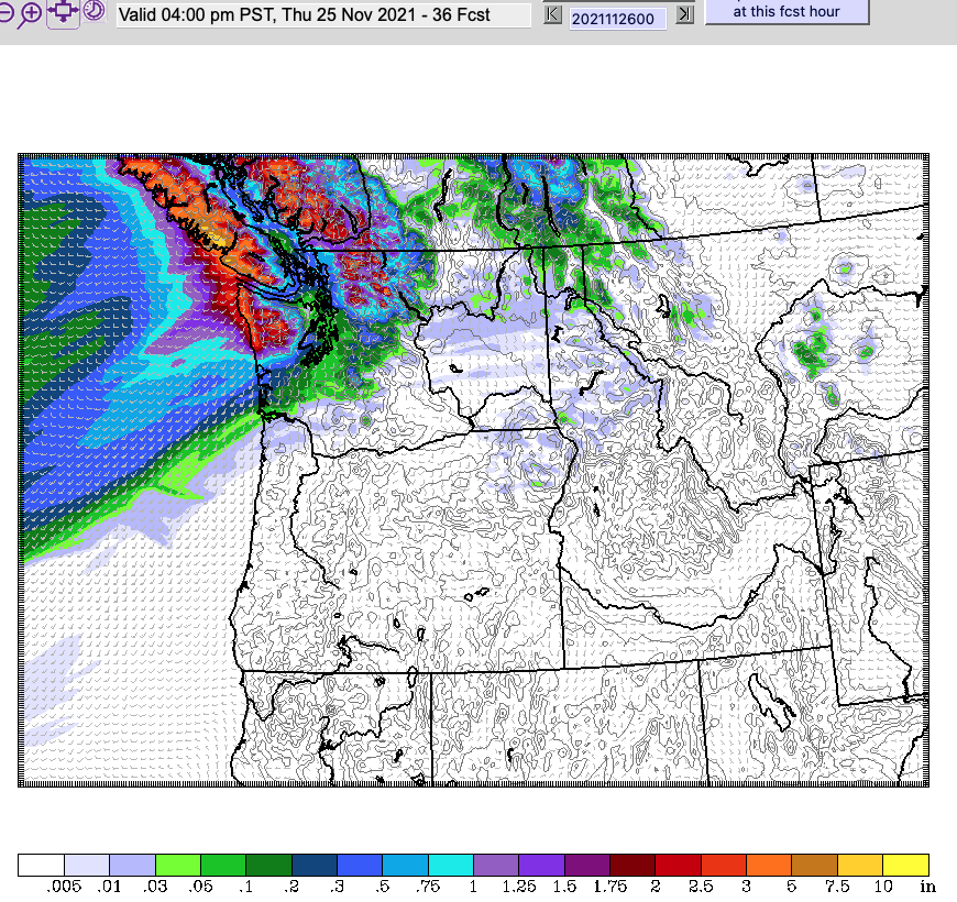
This morning’s model forecast from University of Washington expects heavy rain to begin on the North end of the Island this afternoon and begin to start creeping down the Island by around 4PM.

The first wave of this system will hit the Island tonight in the 7-10PM period but it will be focused on the West side of the Island and Port Alberni. Courtenay, Parksville, Nanaimo and Victoria will stay relatively dry.

The second wave, and the “atmospheric river” feature will hit early Thursday morning. You can see the “river” on the north end of the Island in the image below. By 4AM Thursday it will be raining across the entire South Coast including the Fraser Valley.
Click/Swipe through the images below as the “river” slides down the Island. These images are three-hour periods.
24 hour totals
Judging by the image below of rainfall totals from 4PM Wednesday to 4PM Thursday, we should see 38-50mm of rain in Port Alberni. However, upwards of 100mm will fall in the higher elevations of the Island particularly toward Tofino/Ucluelet, so we should be aware of the potential of flooding on the Stamp/Sproat/Somass and other Valley rivers.


Amounts in the Fraser Valley look to be in the 30-50mm range depending on elevation. This is a typical amount for a November rain storm, but given the current situation, it could lead to more disruption and destruction than normal.
The good news is it looks as though this “river” will continue moving southwards and move into Washington and Oregon State on Friday. So while we will be getting a good 12-24 hours of steady rainfall, it won’t be 48-72hrs of steady rainfall that caused disaster last week.

The rain from this first system should be done by Friday morning. Only a few drizzles will remain.
Snow on Mountains Thursday – Bad setup for Weekend.
Part of the big concern from officials I think is because of the potential for this first wave, which is cooler, to create snow in the mountains. The image below is the 48hr snowfall forecast between Wednesday and Friday afternoon.


The image shows as much as 30-60cm (1-2ft) of snow falling in the coastal ranges. Much less, maybe 15cm is expected on the high peaks of in Strathcona park.
But here’s the problem, this is the snowfall accumulation for the Saturday/Sunday atmospheric river event:

Notice there is a lot less coloured areas near the Fraser Valley, and in particular on the east (right) side of the Fraser River and into the Interior and very little in Washington State. That means rain on the snow, which will melt the snow and add to the rivers. Particularly runoff from Mt. Baker in Washington State into the Nooksak River which was a big reason for the flooding in the Fraser Valley.
Potentially Catastrophic, again, rainfall from Saturday-Tuesday
Saturday will be a bigger rain event, and unfortunately, it looks like the atmospheric river event could stall over us for essentially 5 days. It looks bad. I hope these models are incorrect.
Rain will begin again during the day Saturday for all areas. The model has the river continuing to impact Vancouver Island, all areas, but this time more focused on West Vancouver Island/Port Alberni, and the Fraser Valley until Monday afternoon and then starting up again on Tuesday through Wednesday next week.
Tides also critical
We’ll need to keep an eye on the tides to know when the rivers will be most full, especially in Port Alberni and the Fraser Valley.
Here is a link to the Port Alberni Tide forecast. (Other locations available there too).
You can slide through the upcoming days in the gallery below.
Be prepared – Get the App!
Please be very careful if you most go out. Avoid travelling if you can. Listen to all emergency broadcasts. If you are in the Alberni Valley/ACRD, get the VOYENT ALERT App on your phone! You can search for it on your App Store, install it and add our region for all updates.
Stay safe and as dry as you can. There are sandbags at the City Works yard in Port Alberni and there may be other locations as well.
Take care, Chris.


