It wasn’t nearly as wet as many thought it would be this weekend… today we might get some thunderstorms and this week we should get back to nice warm weather in time for Fall Fair! (Come find me along with a couple other councillor hopefuls at our booth in Glenwood!)
Today (Tuesday) Possible Thunderstorms:
The gods may show their displeasure that our children are not at school… there is thunder in the air!
The models are showing the greatest likelihood for thunderstorms around 2PM this afternoon.
Unlike last month when the turbulent weather came up from the souther, the main force of this unstable weather is coming down from the North and seems centred mainly in the Barklay Sound area and the West Coast.
 But we should be prepared just the same.
The Wet Weekend that Wasn’t
After much worry and gnashing of teeth about a big ‘change in the weather’ heralding rain (10-30 mm) and frowning faces, the rain that was supposed to come didn’t.
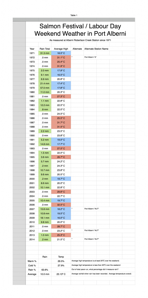
The station at the Airport officially measured 0.2 mm of rain and our average high temperature was 21.5º C
This brings both our average Salmon Derby Weekend rainfall and the high temperature down slightly from 10.4 mm to 10.0 mm and 23.17º C to 23.13º C respectively over the past 43 years.
Here’s the updated spreadsheet as continued from last week. (click for larger view) Warm weather returns:
Once we get through today’s thundershowers, we should see a gradual improvement in the weather. It should feel like summer again as soon as tomorrow and it will really feel like summer on Friday, just in time for the Fair.
More on the fall fair forecast tomorrow.
Happy Tuesday-that-feels-like-Monday everyone!

