Someone on the great alberni.ca forum asked me today: “Chris how do you explain the two prior back to back terrible summers we had? Me, I am enjoying the heck outta this year and hope it continues!”
Short answer: Switch to negative (cool) Pacific Decadal Oscillation.. which has subsequently been overwhelmed by a weak El Nino and record Arctic Sea ice loss. The weather is freaking incredible though, isn’t it! Hard to complain, though todays news about fish stocks on the Island is worrying.
Explanation below:
First, remember this summer didn’t start out great. There was a lot of hand wringing in June-uary that we were into the same thing. July was pretty good but it wasn’t until August that things really took off but nobody saw this coming.
As for the reasons for the last two years of bummer-summer:
Negative (cool) phase of the Pacific Decadal Oscillation (PDO)
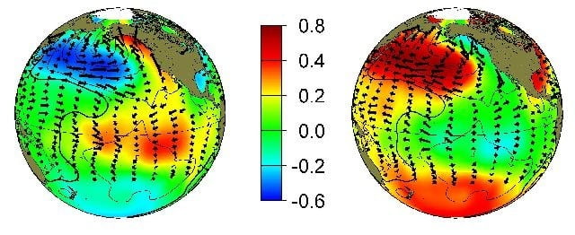
This is what the phases look like, the colors represent warm and cold water and also notice the water/wind directions. The cold PDO has been shown to favour good salmon runs because of increased upwelling and cool water off the coast:

We are in the negative, or cool phase on the right. The “cool” refers to cooler water directly off our Pacific coast.
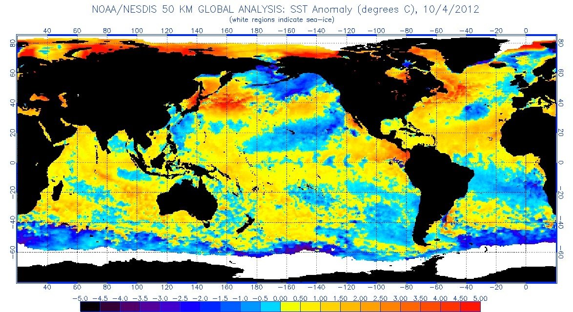
Here is the current Sea surface state on the globe as of October 2012:

You can see the cool waters of the PDO stretching up from California and in the Gulf of Alaska. The big warm anomaly though is pretty far West compared to the example and there is a fair amount of mixed cool and warm water in the Central North Pacific so the PDO cool phase is weaker than it could be.
You can also see the beginnings of El Niño. That’s the warm water stretching out from northern South America.
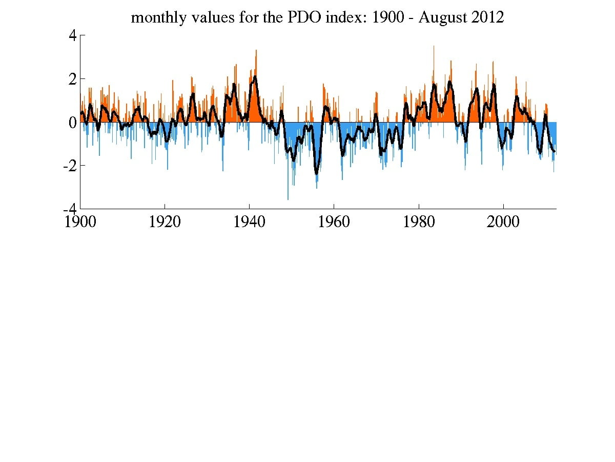
The graph below shows the shifting back and forth between cool and warm phases of the PDO over the past few decades very similar to ENSO (El Nino/La Nina), just on longer time periods.
You should notice in the graph that we haven’t had a serious cold phase since… wait for it… the 1970s! The same time we (that were around) last remember skating on local lakes and ponds.
The PDO is not as strong a force globally as ENSO (a.k.a. El Niño/La Nina)… but it does have an effect on our climate here in the Pacific Northwest just because of its proximity. Plus, if you are an avid watcher of “Deadliest Catch” you’d know that last year was a terrible year for sea ice in the Bering Sea. This was a direct result of the PDO. Many climate skeptics were actually announcing that the PDO was effectively going to ‘save us’ and the ice was on its way to recovery. Unfortunately, there is a lot more Arctic than the Bering Sea and it all melted out anyway so we’re now back to zero.
The PDO also combined last year with a La Nina, which would further cool the Eastern Pacific… and make things generally cold and yucky around here.
The U Washington in the first link above explains it in great detail.
So finally, The reason this year was different, in my completely speculative, layman’s opinion is:
#1: La Nina weakened in the beginning of the year… and went neutral. It is now a weak El Nino.This likely allowed for us to get into our ‘normal’ summer pattern in late July and early August.
#2: Arctic sea ice then took over. As the ice rapidly melted and the Arctic Ocean and atmosphere warmed this reduced the difference in temperature between the high and low lattitudes, which slowed the meanderings of the jet stream, and caused it to become essentially stationary for weeks. This caused the long period of high pressure over the NE Pacific and BC and pushed all the pacific ‘pineapple express’ systems in late August and through September into Alaska (where they have had major windstorms and flooding)
So unlike the 1970s, where the PDO could clearly grip our part of the world in its cold hands, now things are different. The Earth itself is warmer which dampens the cool PDO, strengthens any El Nino events, and now adds in the Arctic sea ice loss to excessively warm the polar region, melt the sea ice and really screw with our weather patterns in ways we haven’t fully quantified or qualified fully yet.
If the theory scientists have about the ice-free Arctic causing the jet stream to effectively get stuck turns out to be true, then it will mean BOTH extended periods of drought like this… OR extended periods of being pounded by Pacific Storms (as has been the case in Alaska). The phase of the PDO and ENSO at the time, might simply control a bit of the character or strength of those events.


Comments
2 responses to “What happened to the bummer summer?”
Great synopsis of our weather situation. Really ties the local ad global scenes together!! Thanks.
You’re welcome, and thank You for visiting 🙂