UPDATE 9:00PM
The Wind Warning has ended. Port Alberni escaped mostly unscathed. Our strongest gust was 54kph around 12:30PM today. Other parts of the Island didn’t fare as well and nearly 33,000 people are without power right now, mostly in the Cowichan Valley.
UPDATE 4:00PM
The wind warning has been continued for our area. The south is, and especially Cowichan Valley has felt the brunt of this storm so far but the threat still exists. We will see what happens. Stay tuned.
UPDATE 1:45PM
The wind has abated slightly. Our peak wind gust so far is 54.7kph around 12:25PM. The meat of the storm is yet to come though. Here is the highest resolution model of wind gusts for the 1-4PM hour when the winds will peak.
There will be 60knot gusts off of Tofino, Ucluelet, Bamfield, Port Renfrew, Victoria and Vancouver (particularly Tsawassen terminal). Expect lots of ferry delays this afternoon and evening.
We will just have to see how this affects us. We’ve already got a good amount of wind. There is a power outage at the Lake and out Beaver Creek affecting around 50 customers total but the South Island as a whole has 46,000 people without power at last check.
Stay safe and enjoy the show!
UPDATE 12:25PM
The wind continues to build… already significant power outages, affecting over 24,000 customers, on the South and West Island but nothing in Port Alberni just yet. If you have pictures or videos please do share them. alberniweather@gmail.com or @Alberniweather or on Facebook or here in the Comments.
UPDATE 11:45AM
Gusts starting to increase – latest highest gust – 49.9kph from South. Barometer starting to level off at 99.96kPa.
UPDATE 11:00AM – Whopper Low coming in with 75+knot following winds:
IMPORTANT – READ THROUGH TO END OF UPDATE
Environment Canada has continued the Wind Warning for our area:
Southwesterly winds 60 km/h gusting to 90 will develop this afternoon In the wake of the system, Winds will ease this evening as the low moves inland.
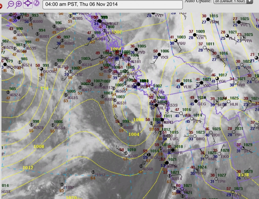
And they are not keeping that this is a deep and powerful low. The just completed morning model runs has this impressive image for the 7-10AM period just passed as the low approaches the Island.

The model shows the low impacting slightly south of where it predicted last night… which gives a higher potential of high winds in our area:

After 1PM you can see the pressure lines stack up along the west coast of the Island. This is likely to cause major wind.

We are also setting records on the Island for temperature. Nanaimo is the current hotspot at 17º C. Alberniweather is currently reporting 15ºC. Our record for the day is 16.6ºC at the Airport. The wind should bring more warmth.
End of 11AM UPDATE
_____________
Environment Canada has issued a rare Wind warning for our area.
Southwesterly winds 60 km/h gusting to 90 will develop this afternoon In the wake of the system, Winds will ease this evening as the low moves inland.


The second image from last nights model shows strong southerly gusts to 50knots (90kph) or more on the West Coast should be occurring now.
And indeed, the lighthouse report right now shows Cape Beale (near Bamfield) with gusts to 50 knots and Amphitrite Point (outside Ucluelet) gusting to 40knots.
Rain First For Us.
It is already raining and it will rain pretty hard this morning peaking before 11AM.

Once the rain passes the wind should shift to strong northwesterlies on the Coast and strong SouthEasterlies.
i will update this post throughout the day of there are newsworthy changes.
Stay safe out there and enjoy the weather!


