1:00PM Update – Winter Storm Warning Continued
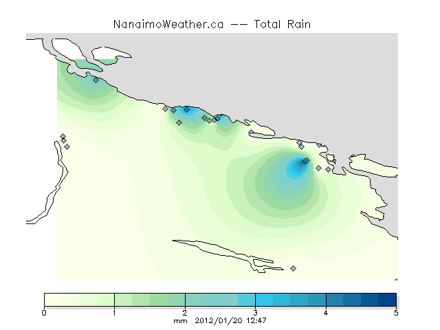
We have been in a bit of a holding patter as it has been drizzling across the Island since at least 6:00AM this morning. However, you will note that Islandweather.ca is only showing measureable precipitation in a few spots, and none in Port Alberni.
That’s because it has stayed below freezing in most of those areas and so the rain has fallen as sleet, wet-snow, or freezing rain.
This pattern will break soon. The meat of this system *should* finally start giving us some real precipitation soon. If it comes down hard, there is a chance it will fall first as snow (the heavy moisture will cool the air more) or as more substantial freezing rain.
We are really just waiting for the warm air that Tofino, Ucluelet and Bamfield are already getting (it’s +6C out there) to come up the Inlet and invade the Valley.
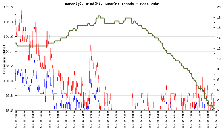
You will also notice the Barometer is currently falling off a cliff.
That is a harbinger of the wind to come. We still have a few kPa to go before it bottoms out and the wind hits. Look for it to go below 98.0kPa and for the wind to pick up just before or just after it jogs upwards.
End Update
7:30AM Update
It was Sleeting or freezing drizzle when I left my house at 6:15. It was the same from Port to Parksville. No big snow accumulations. Roads are Slushy with patches of crusted ice.
It looks unlikely that we will get any more snow from now on. I think it could be a full morning of this sleety stuff followed hopefully by some warm southwest winds and switch to rain. Basically, not as bad as it could have been.
That said, it will be bad in the Fraser Valey where temps are still well below zero and freezing rain is already accumulating.
We will see later on today whether we get any serious wind and what the wind might do in other areas around the south coast.
End Update
6:00AM Update
The Storm is late coming… or more accurately, the first part of the ‘blob’ looks to have just brushed past to the North. As a result we only got about 2cm of snow overnight. However, the Winter Storm Warning remains. 5cm of snow is expected to fall now before it turns to freezing rain, then rain tonight.
The GFS and NAM models both have the heaviest precipitation now coming between 1PM and 6PM today with a total of 30-40mm of precipitation possible. Environment Canada is predicting 10-20mm of ice accretion for the Fraser Valley and Howe Sound so could be a major problem for them.
Winds should pickup in the afternoon as well. We do not have a warning, but all other areas of the Island are expecting 60-90kph winds.
Be careful on the roads. Most are reporting compact snow or slushy/slippery sections.
Inland Vancouver Island
4:54 AM PST Friday 20 January 2012
Winter storm warning for
Inland Vancouver Island continuedSnowfall amounts up to 5 cm are expected this morning except up to 10 cm today for Eastern Fraser Valley, Howe Sound and Whistler. Whistler will have an additional 15 cm tonight. Areas of freezing rain near the coast this morning will spread inland this afternoon.
Southeast winds of 90 km/h will occur over Central Coast – coastal sections today.
Southeast winds of 60 to 80 km/h will develop over East Vancouver Island and Sunshine Coast this afternoon.
Northeast outflow winds of 100 km/h will persist today over the North Coast – coastal sections.
This is a warning that dangerous winter weather conditions are expected or occurring in these regions. Monitor weather conditions..Listen for updated statements.
A significant winter storm with snow, areas of strong winds and freezing rain is expected today and tonight. Further snowfall accumulations of up 5 cm are expected this morning except amounts may reach 10 cm today over the Eastern Fraser Valley, Howe Sound, Whistler and North Coast – coastal sections. Further snowfall amounts of 15 cm will occur in Whistler tonight. In addition strong southeast winds of 90 km/h will develop over North Vancouver Island, Central Coast – coastal sections and Haida Gwaii this morning. Meanwhile very strong outflow winds gusting to 90 km/h combined with 10 to 15 cm of new snow will create blizzard conditions for North Coast – inland sections through this evening.
Through today over the south coast there will be a transition to mild and moist Pacific air due to a strengthening southerly flow. Most regions can expect periods of freezing rain this morning before the changeover to rain occurs. An extended period of freezing rain is forecast for the Fraser Valley and Howe Sound later today and through most of tonight with 10 to 20 mm of ice accretion likely. Meanwhile, southeast winds of 60 to 80 km/h will develop over East Vancouver Island and Sunshine Coast this afternoon and then over Greater Victoria and Southern Gulf Islands this evening. Southeast winds of 80 km/h will also develop over West Vancouver Island this afternoon. Winds in Victoria and Southern Gulf Islands will shift to southwest 50 km/h gusting to 90 early Saturday morning.
End Of Update
9:45PM Update:
They’ve updated the warnings so I’ve updated the text below. It seems to get longer and longer. They’ve now officially added wind-warning class notices for the East Coast and Sunshine Coast of 60-80kph winds for Friday afternoon.
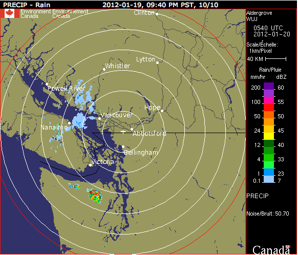
I’ve heard it’s snowing lightly i Nanaimo and judging by the radar, likely points north along Oceanside and Powell River too.
This is just little stuff coming down from the north though the main brunt (blob) won’t make landfall for another couple hours.
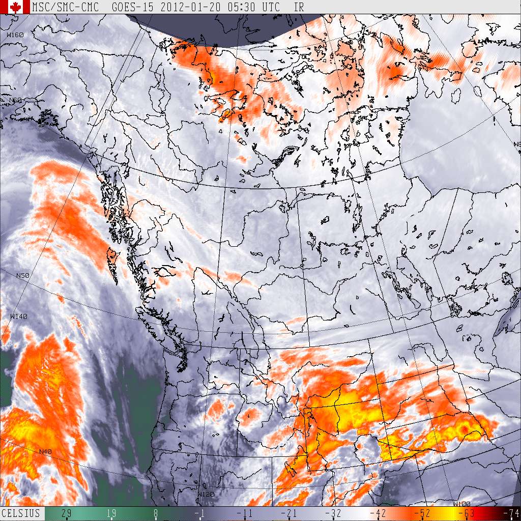
The 9:30PM PST Satellite image
End Update
7:30PM Update:
Doing the totally un-super-scientific eyeballing of the Pacific Satellite Animation it looks like the ‘blob’ (also the super-scientific-name for such things) should hit us and the snow start to fall around 11PM or Midnight.
That is all.. 🙂
End Update
5:30pm Update:
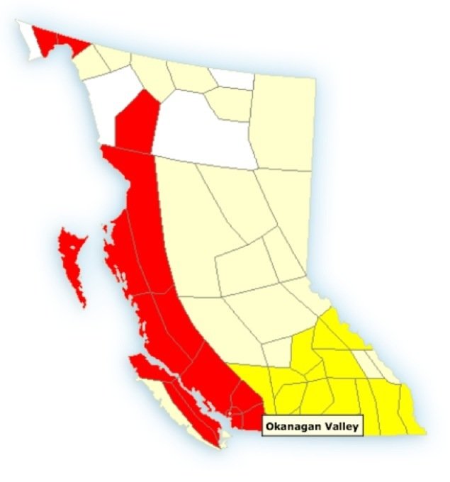
The Province is On Alert: You can see below the entire West and Southern parts of BC are under a Warning (red) or Watch (yellow) and while I have not clicked them all I am confident most are Winter Storm events with at least two of snow, freezing rain, or wind advisories.
The precipitation should start in earnest around 8-10PM tonight (snow first), when the change to freezing rain and rain happens is very hard to say and will totally depend on where you are. I expect the snow to hang on longer in Port, and especially in the Creeks and Lake. Around noon switch to freezing rain then Afternoon or evening to just rain. But we will see.
Please don’t be shy, leave a comment here or on Facebook or Twitter if you see conditions changing in your neighbourhood.
End of Update (I did update the warning text quoted)
Click the links below to see the updated East Coast and Inland warnings.
I will keep this post up all day tomorrow and just make updates.
Inland and East Coast now have Winter Storm Warnings.
If you do not need to drive anywhere tomorrow, then it will be best not to until you see and feel warm rain falling. (And that may not happen until Friday night)
Details below:
Inland Vancouver Island
9:10 PM PST Thursday 19 January 2012
Winter storm warning for
Inland Vancouver Island continuedSnowfall amounts from 5 to 10 cm are expected through Friday morning. Freezing rain will also develop Friday morning near the coast and spread inland during the afternoon.
Southeast winds of 90 km/h will develop Friday morning over the Central Coast – coastal sections and Haida Gwaii.
Southeast winds of 60 to 80 km/h will develop over East Vancouver Island and Sunshine Coast Friday afternoon.
Northeast outflow winds of 100 km/h will persist on Friday over the North Coast – coastal sections. Wind chill values near minus 20 for Fraser Valley – east tonight.
This is a warning that dangerous winter weather conditions are expected or occurring in these regions. Monitor weather conditions..Listen for updated statements.
An Arctic ridge of high pressure over the British Columbia interior is producing moderate outflow winds through coastal valleys and inlets. These winds in combination with cold air will produce wind chill values near minus 20 tonight for Central Coast – inland sections and Fraser Valley – east and minus 35 for North Coast – inland sections.
A significant winter storm with snow, areas of strong winds and freezing rain is expected tonight and Friday. Snowfall accumulations of 10 to 15 cm are expected over Haida Gwaii, Central Coast – coastal sections and North Coast – coastal sections tonight and a further 10 to 20 cm is expected for North Coast – coastal sections on Friday. In addition strong southeast winds of 90 km/h will develop over North Vancouver Island, Central Coast – coastal sections and Haida Gwaii Friday morning. Meanwhile very strong outflow winds gusting to 90 km/h combined with new snow will create blizzard conditions for North Coast – inland sections overnight through Friday.
On Friday there will be a transition to mild and moist Pacific air over the south coast due to a southwesterly flow. Snowfall amounts of 5 to 15 cm is expected for the south coast with the lower amounts expected near the coast. All areas can expect snow to become mixed with freezing rain as the changeover to rain occurs. An extended period of freezing rain is expected for the Fraser Valley and Howe Sound with 10 to 20 mm of ice accretion likely.

Comments
7 responses to “Updated: Winter Storm Warning Issued – Central and East Island”
As of 5 AM Fri. not so much as a drop of precipitation or a breeze at Sproat Lake. Kind of eerie waiting for this big wallop and yet nothing
It is strange Tom. Certainly does seem to be on its way though. Was really hoping I wouldn’t have to travel over the hump today, but looks like I don’t have a choice now.
We’ll see if I end up turning around half way to VIU like Wednesday.
Hmmm, a little disappointing so far, and the temperature is only going to increase from now on, so I think this will mainly be a rain event. My son will be disappointed too, because he was expecting a day off school!
We;re getting light wet snow out towards the lake
Let’s hope the freezing rain doesn’t last much longer. Already getting little icicles in the trees. I was in Montreal for a big freezing rain storm, it was terrible hearing all the trees snapping one after another.
There was literally big gobs of slush raining down for a few minutes.
Ya. The temperature is steadily creeping upward…. lets hope it keeps creeping.